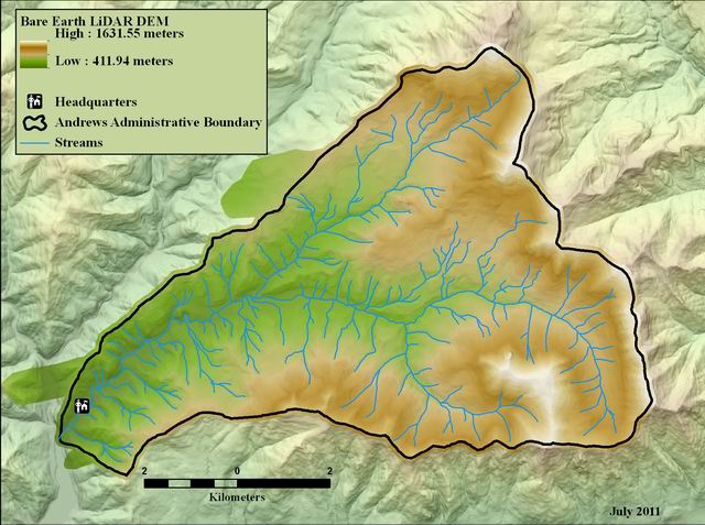
Bare earth digital elevation model (DEM) from 2008 LiDAR, Andrews Experimental Forest
Raster Dataset

Tags
topography, HJ Andrews
Experimental Forest, Landscape Ecology, Oregon, geology, Blue River Watershed, LiDAR,
digital elevation model (DEM), Willamette Basin
The LiDAR laser returns were processed into a representation of the topography of the area of interest with all the vegetation removed, also known as the "Bare Earth Digital Elevation Model (DEM)l". The final product is in ESRI GRID digital format, with a 1 meter cell size resolution. Each cell in the GRID has a value that represents the modeled elevation at that location. The purpose of the data is to provide users with a very accurate view of the topography of the study area. The data are suitable for creating visualizations, deriving watershed boundaries, creating stream networks, identifying structures such as roads and water features, and for identifying landslides and geological features,
Watershed Sciences, Inc. (WS) collected Light Detection and Ranging (LiDAR) data from HJ Andrews and the Willamette National Forest (NF) on August 10th and 11th 2008. Total area for this AOI is 17,705 acres. The total area of delivered LiDAR including 100 m buffer is 19,493 acres. This raster contains the bare-earth Digital Elevation Model for the Andrews Forest. The zip file contains an ArcInfo export file (.e00) .
Data set was created by Watershed Sciences, Inc http://www.watershedsciences.com/
While substantial efforts are made to ensure the accuracy of data and documentation, complete accuracy of data sets cannot be guaranteed. All data are made available "as is". The Andrews LTER shall not be liable for damages resulting from any use or misinterpretation of data sets.
Extent
West -122.277460 East -122.099580 North 44.282961 South 44.196797
Maximum (zoomed in) 1:5,000 Minimum (zoomed out) 1:50,000