Shapefile
Tags
Blue River
Watershed, Oregon, geomorphology, landslide, WIllamette Basin, HJ Andrews,
earthflow
To support research management i.e. study site selection, infrastructure improvement, and climate summaries within the HJ Andrews Experimental Forest
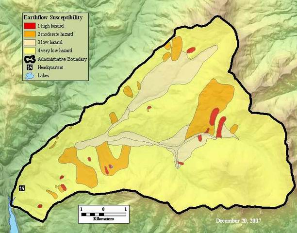
Earthflow susceptibility based on soil classification data.
There are no credits for this item.
While substantial efforts are made to ensure the accuracy of data and documentation, complete accuracy of data sets cannot be guaranteed. All data are made available "as is". The Andrews LTER shall not be liable for damages resulting from any use or misinterpretation of data sets.
Extent
West | -122.262494 | East | -122.100927 |
North | 44.281987 | South | 44.197475 |
Maximum (zoomed in) | 1:5,000 |
Minimum (zoomed out) | 1:150,000,000 |
publication date
Access constraints: Available on Line
Use constraints: See data access policy at www.fsl.orst.edu/lter/data.cfm (especially the data use policy)
While substantial efforts are made to ensure the accuracy of data and documentation, complete accuracy of data sets cannot be guaranteed. All data are made available "as is". The Andrews LTER shall not be liable for damages resulting from any use or misinterpretation of data sets.
Obtain the data from the website: http://www.fsl.orst.edu/lter/datafr.htm Call the distribution number if you can not access the website.
Earthflow Susceptibility Polygon Attribute Table
FSLDOC metadata
Internal feature number.
ESRI
Feature geometry.
ESRI
Area of feature in internal units squared. (square meters)
ESRI
Perimeter of feature in internal units. (meters)
ESRI
Internal feature number.
ESRI
User-defined feature number.
esri
user defined unique numbers
esri
unique whole numbers, user defined. meaning unclear
esri
Distribution of unstable soil
FSL DOC metatdata
earthflow susceptibility code
FSL DOC metadata
Earthflow susceptibility based on soil classification data.
To support research management i.e. study site selection, infrastructure
improvement, and climate summaries within the HJ Andrews Experimental Forest
publication date
Available on Line
See data access policy at www.fsl.orst.edu/lter/data.cfm (especially the data use
policy)
Relatively good, but include unknown things such as distribution of thick
colluvium
.
Fred Swanson, George Lienkaemper, Futoshi Nakamura
Derived from soils attributes Digitized in-house
Dataset copied.
Dataset copied.
While substantial efforts are made to ensure the accuracy of data and
documentation, complete accuracy of data sets cannot be guaranteed. All data are made
available "as is". The Andrews LTER shall not be liable for damages resulting from any
use or misinterpretation of data sets.
Local area network
Obtain the data from the website: http://www.fsl.orst.edu/lter/datafr.htm
Call the distribution number if you can not access the website.