Shapefile
Tags
Willamette National
Forests, vegetation, managed forests, Oregon, HJ Andrews Experimental Forest, natural
forests
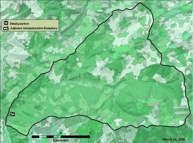
To provide information on vegetation distribution of the HJ Andrews
Vegetation map of the HJ Andrews, created by the Willamette National Forest l created from SPOT imagery and aerial photos
There are no credits for this item.
See data access policy at www.fsl.orst.edu/lter/data.fr.htm (especialy the data use policy)
Extent
West | -122.268450 | East | -122.095390 |
North | 44.286702 | South | 44.192727 |
Maximum (zoomed in) | 1:5,000 |
Minimum (zoomed out) | 1:150,000,000 |
publication date
While substantial efforts are made to ensure the accuracy of data and documentation, complete accuracy of data sets cannot be guaranteed. All data are made available "as is". The Andrews LTER shall not be liable for damages resulting from any use or misinterpretation of data sets.
Available on-line
See data access policy at www.fsl.orst.edu/lter/data.fr.htm (especialy the data use policy)
Obtain information off of WWW site, call contact person for special requests.
arcgis shapefile polygon feature
esri
Internal feature number.
ESRI
Feature geometry.
ESRI
Area of feature in internal units squared.
ESRI
Perimeter of feature in internal units.
ESRI
internally generated unique number
esri
user defined unique feature value
esri
Stand. Seven digit index number for the polygon
Willamette National Forest data dictionary
Year of origin for both natural and managed stands.
Willamette National Forest data dictionary
Size classification. Size class of layer 1 (r6 size class codes). The predominant size class of all trees in a given layer of a stand based on diameter at breast height, with a minimum height of 6" for size class 1. Note: size class information is sparse for managed stands. This information is best for natural stands.
Willamette National Forest data dictionary
Species 1 (major species). Most abundant tree species in primary canopy layer in a managed or natural stand (pnw6 char plant code) within National Forest land.
Species 2 (minor species). Second most abundant tree species in secondary canopy layer in a manged or natural stand (pnw6 char plant code) on National Forest land.
Number of layers. Estimated number of canopy layers in the stand for forested stands.
Willamette National Forest data dictionary
Last overstory cut. Activity code for the most recent overstory cut.
Willamette National Forest data dictionary
Last overstory year. Year of the last clearcut or overstory removal.
Willamette National Forest data dictionary
Last partial cut. Activity code for the most recent partial cut.
Willamette National Forest data dictionary
Last partial year. Year of the last partial cut
Willamette National Forest data dictionary
Commercial thin year. Year of the last commercial thinning activity record.
Timber type. Timber types are classifications of stand species composition from the original timber inventory used in the development of the Forest Plan. These classifications, in association with timber size, are used to identify the correct yield table for ASQ and PSQ calculations. (INTERIM FIELD).
Willamette National Forest data dictionary
Condition class (INTERIM FIELD). Classification based on size class for natural stands & managed stands with non-regenerative harvest (partial) cuts for clearcuts, overstory removals & partial cuts with evidence of regeneration.
Willamette National Forest data dictionary
Land cover. Land cover classification divides the land surface into categories based upon feature of the earth surface (vegetation, rock, ice/snow,water, etc.)
Land use. Land use classification divides the land surface into categories based on the way the land is used (green tree retention, special habitats, buildings, etc.) This is a multiple field.
Willamette National Forest data dictionary
Habitat features. Habitats with distinct features that occur in stand which my be important when considering management practices.
Cover percent of trees. The percent of ground area covered by the vertical projection of live foliage of all trees in all tree layers in a stand. Small openings in the canopy are included. Overlapping foliage is counted only once. Canopy cover cannot exceed 100%. See vegis data dictionary for examples.
Willamette National Forest data dictionary
Plant association. The potential natural plant community, defined as discrete, recurring collections of plant species which maintain stable populations over a long period of time. In some cases only a general classification of plant association is known for a polygon. These polygons are coded with a 2 character code and general description. Codes beginning with "A" will be migrated to "land_use." Codes ending in C0 (zero) were sometimes coded as CO in the database. This error will be corrected, but queries for that information need to include CO and C0.
Land ownership on Willamette National Forest within the proclamation boundary.
Willamette National Forest data dictionary
Vegetation map of the HJ Andrews, created by the Willamette National Forest l created from SPOT imagery and aerial photos
To provide information on vegetation distribution of the HJ Andrews
publication date
Available on-line
See data access policy at www.fsl.orst.edu/lter/data.fr.htm (especialy the data use policy)
very good
very good
The VEG table exists in both Oracle and INFO databases. It was originally developed from queries of the district VEGIS database (oracle) and then transferred to INFO and attached to the VEG layer in GIS. Most attention was given to populating the following fields: yr_origin, size_class, land_use, land_cover, and activity. No attempt was made to ensure that all other fields were populated. This forestwide coverage was compiled from district data July, 2000. Forestwide coverages are compiled from district information as needed, on average every 6 months. The currency of data for individual polygons varies across the forest depending on district update and edit cycles.
Metadata imported.
Metadata imported.
Metadata imported.
Dataset copied.
Dataset copied.
While substantial efforts are made to ensure the accuracy of data and documentation, complete accuracy of data sets cannot be guaranteed. All data are made available "as is". The Andrews LTER shall not be liable for damages resulting from any use or misinterpretation of data sets.
Obtain information off of WWW site, call contact person for special requests.