Shapefile
Tags
Willamette National Forests,
vegetation, managed forests, Oregon, HJ Andrews Experimental Forest, natural
forests
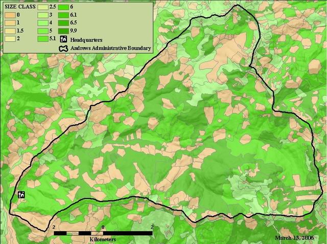
To provide information on vegetation distribution of the HJ Andrews
Vegetation map of the HJ Andrews, created by the Willamette National Forest l created from SPOT imagery and aerial photos
There are no credits for this item.
See data access policy at www.fsl.orst.edu/lter/data.fr.htm (especialy the data use policy)
Extent
West | -122.268448 | East | -122.095393 |
North | 44.284748 | South | 44.190779 |
Maximum (zoomed in) | 1:5,000 |
Minimum (zoomed out) | 1:150,000,000 |
publication date
While substantial efforts are made to ensure the accuracy of data and documentation, complete accuracy of data sets cannot be guaranteed. All data are made available "as is". The Andrews LTER shall not be liable for damages resulting from any use or misinterpretation of data sets.
Available on-line
See data access policy at www.fsl.orst.edu/lter/data.fr.htm (especialy the data use policy)
Obtain information off of WWW site, call contact person for special requests.
shapefile polygon coverage
esri
Internal feature number.
ESRI
Feature geometry.
ESRI
user defined unique value
esri
acres
Willamette NF Data Dictionary
polygon index number
Willamette NF Data Dictionary
year of origin
Willamette NF Data Dictionary
/data/fordata/oregon/willamette/hjandrews/hjaveg (Word doc)
ranger district
R6 size class of canopy layer 1
Willamette NF Data Dictionary
flag
Willamette NF Data Dictionary
Willamette National Forest quad sheet index numer
Willamette NF Data Dictionary
predicted natural vegetation, based on elevation, aspect, and eco-zone
Willamette NF Data Dictionary
vegetation code
Willamette NF Data Dictionary
primary species of reproduction in managed stands
Willamette NF Data Dictionary
secondary species of reproduction in managed stands
Willamette NF Data Dictionary
number of canopy layers in natural stands
year of origin for reprod in managed stands
Willamette NF Data Dictionary
activity code for most recent clearcut or overstory removal
Willamette NF Data Dictionary
year of last clearcut or overstory removal
Willamette NF Data Dictionary
activity code for most recent parital cut
Willamette NF Data Dictionary
year of last partial cut
Willamette NF Data Dictionary
year of regen certification
Willamette NF Data Dictionary
year of last commercial thinning
Willamette NF Data Dictionary
predicted potential natural vegetation
Willamette NF Data Dictionary
seral stage classed based on stand age
Willamette NF Data Dictionary
primary species in canopy layer 1
secondary species in canopy layer 1
Willamette NF Data Dictionary
primary species in canopy layer 2
classification base on canopy composition
Willamette NF Data Dictionary
classed based on natural stand size class and managed stand
Willamette NF Data Dictionary
unknown
Willamette NF Data Dictionary
unknown
Willamette NF Data Dictionary
HJA harvest unit designation
Willamette NF Data Dictionary
Vegetation map of the HJ Andrews, created by the Willamette National Forest l
created from SPOT imagery and aerial photos
To provide information on vegetation distribution of the HJ Andrews
publication date
Available on-line
See data access policy at www.fsl.orst.edu/lter/data.fr.htm (especialy the data
use policy)
very good
very good
Created by WNF using aerial photography and satellite imagery. George
Lienkaemper imported, clipped, and did some edits in 1997.
Metadata imported.
Metadata imported.
While substantial efforts are made to ensure the accuracy of data and
documentation, complete accuracy of data sets cannot be guaranteed. All data are made
available "as is". The Andrews LTER shall not be liable for damages resulting from any
use or misinterpretation of data sets.
Obtain information off of WWW site, call contact person for special
requests.