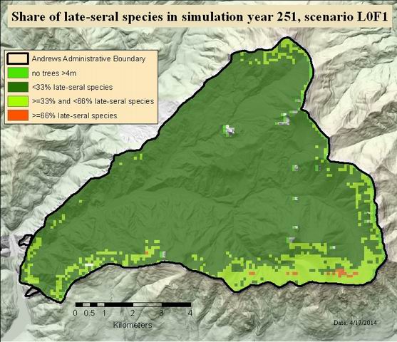
Share of late-seral species in simulation year 251, scenario L0F1

Raster Dataset
Thumbnail

Tags
Blue River Watershed, Willamette Basin, Oregon, HJ Andrews Experimental Forest


Summary

The purpose of this study was to determine the role and contribution of biological legacies to the resilience of the HJ Andrews landscape after large, high severity fire. Resilience is quantified for three indicators, i.e., total ecosystem carbon storage, canopy complexity (rumple index), and presence of late-seral species on the landscape.

Description

Simulation results for the scenario with no initial biological legacy and historic fire return interval

Disturbances are key drivers of forest ecosystem dynamics, and forests are well adapted to their natural disturbance regimes. However, as a result of climate change, disturbance frequency is expected to increase in the future in many regions. It is not yet clear how such changes might affect forest ecosystems, and which mechanisms contribute to (current and future) disturbance resilience. We here studied the 6364-ha HJ Andrews Experimental Forest landscape to investigate how patches of remnant old-growth trees (as one important class of biological legacies) affect the resilience of forest ecosystems to disturbance. Using the spatially explicit, individual-based forest landscape model iLand we analyzed the effect of three different levels of remnant patches (0%, 12%, and 24% of the landscape) on 500-year recovery trajectories after a large, high severity wildfire. In addition, we evaluated how three different levels of fire frequency (no fire, a historic fire return interval of 262 years, and a reduced fire return interval of 131 years) modulate the effects of initial legacies. The study investigated effects of legacies on the resilience of forest ecosystem structure (represented by canopy complexity as described by the rumple index), composition (proportion of late-seral species), and functioning (total ecosystem carbon storage). For each scenario of initial legacy and fire return interval 25 replicates were simulated. More information on the simulation methodology as well as the code and executable used for this study can be obtained at http://iLand.boku.ac.at. The dataset is completed and no further analyses are planned at this point. The results are published in Ecological Applications http://dx.doi.org/10.1890/14-0255.1.

Credits

Use limitations

While substantial efforts are made to ensure the accuracy of data and documentation, complete accuracy of data sets cannot be guaranteed. All data are made available "as is". The Andrews LTER shall not be liable for damages resulting from any use or misinterpretation of data sets.

Extent

West  -122.261948    East  -122.100517
North  44.281483    South  44.197514

Scale Range
Maximum (zoomed in)  1:5,000
Minimum (zoomed out)  1:150,000,000

ArcGIS Metadata 

Topics and Keywords 

Themes or categories of the resource  environment


*Content type  Downloadable Data
Export to FGDC CSDGM XML format as Resource Description No

Place keywords  Blue River Watershed, Willamette Basin, Oregon, HJ Andrews Experimental Forest

Thesaurus
Title Andrews Forest Place Keyword List


Theme keywords  carbon cycling, disturbance, disturbance ecology, disturbance processes, ecosystem dynamics, ecosystem function, ecosystem modeling, fire, forest composition, forest structure, landscape dynamics, landscape modeling, landscape structure,, population modeling, resistance and resilience, secondary succession, trees, vegetation modeling

Thesaurus
Title Andrews Forest LTER Thesaurus


Citation 

Title Share of late-seral species in simulation year 251, scenario L0F1
Publication date 2014-04-21 00:00:00


Edition 1


Presentation formats* digital map


Other citation details tp12505


Citation Contacts 

Responsible party
Organization's name Forest Science Data Bank
Contact's role  publisher


Contact information
Address
Delivery point Corvallis, OR


Responsible party
Individual's name Rupert Seidl
Organization's name Institute of Silviculture, Department of Forest- and Soil Sciences, University of Natural Resources and Life Sciences (BOKU), Vienna, Austria
Contact's position Researcher
Contact's role  originator


Contact information


Resource Details 

Dataset languages  English (UNITED STATES)
Dataset character set  utf8 - 8 bit UCS Transfer Format


Status  completed
Spatial representation type* grid


*Processing environment Microsoft Windows 7 Version 6.1 (Build 7601) Service Pack 1; Esri ArcGIS 10.1.1.3143


ArcGIS item properties
*Name tp12505
*Location file://P:\FSDB\tp125\originals\new_grids\tp12505
*Access protocol Local Area Network

Extents 

Extent
Description
publish date for paper
Temporal extent
Date and time 2014-05-01 00:00:00

Extent
Geographic extent
Bounding rectangle
Extent type  Extent used for searching
*West longitude -122.261948
*East longitude -122.100517
*North latitude 44.281483
*South latitude 44.197514
*Extent contains the resource Yes

Extent in the item's coordinate system
*West longitude 558974.939202
*East longitude 571774.939202
*South latitude 4894202.866233
*North latitude 4903402.866233
*Extent contains the resource Yes

Resource Points of Contact 

Point of contact
Individual's name Theresa Valentine
Organization's name Corvallis Forest Science Laboratory
Contact's position Spatial Information Manager
Contact's role  point of contact


Contact information
Phone
Voice 541-750-7333
Fax 541-750-7760

Address
Type both
Delivery point 3200 SW Jefferson Way
City Corvallis
Administrative area Oregon
Postal code 97332
Country US
e-mail addresstvalentine@fs.fed.us or theresa.valentine@orst.edu

Hours of service m-f 0800-1630


Resource Maintenance 

Resource maintenance
Update frequency  not planned


Resource Constraints 

Legal constraints
Access constraints  other restrictions


Other constraints
Access constraints: Available on-line
Legal constraints
Use constraints  other restrictions


Other constraints
Use constraints: See data access policy at www.fsl.orst.edu/lter (especially the data use policy)
Security constraints
Classification  unclassified


Constraints
Limitations of use
While substantial efforts are made to ensure the accuracy of data and documentation, complete accuracy of data sets cannot be guaranteed. All data are made available "as is". The Andrews LTER shall not be liable for damages resulting from any use or misinterpretation of data sets.

Spatial Reference 

ArcGIS coordinate system
*Type Projected
*Geographic coordinate reference GCS_North_American_1983
*Projection NAD_1983_UTM_Zone_10N
*Coordinate reference details
Projected coordinate system
Well-known identifier 26910
X origin -5120900
Y origin -9998100
XY scale 450445547.3910538
Z origin -100000
Z scale 10000
M origin -100000
M scale 10000
XY tolerance 0.001
Z tolerance 0.001
M tolerance 0.001
High precision true
Latest well-known identifier 26910
Well-known text PROJCS["NAD_1983_UTM_Zone_10N",GEOGCS["GCS_North_American_1983",DATUM["D_North_American_1983",SPHEROID["GRS_1980",6378137.0,298.257222101]],PRIMEM["Greenwich",0.0],UNIT["Degree",0.0174532925199433]],PROJECTION["Transverse_Mercator"],PARAMETER["False_Easting",500000.0],PARAMETER["False_Northing",0.0],PARAMETER["Central_Meridian",-123.0],PARAMETER["Scale_Factor",0.9996],PARAMETER["Latitude_Of_Origin",0.0],UNIT["Meter",1.0],AUTHORITY["EPSG",26910]]

Reference system identifier
*Value 26910
*Codespace EPSG
*Version 7.11.2


Spatial Data Properties 

Georectified Grid
*Number of dimensions 2


Axis dimensions properties
Dimension type  column (x-axis)
*Dimension size 128
*Resolution  100.000000 Meter

Axis dimensions properties
Dimension type  row (y-axis)
*Dimension size 92
*Resolution  100.000000 Meter

*Cell geometry  area
*Point in pixel  center


*Transformation parameters are available Yes


*Check points are available No


Corner points
*Point 558974.939202 4894202.866233
*Point 558974.939202 4903402.866233
*Point 571774.939202 4903402.866233
*Point 571774.939202 4894202.866233

*Center point 565374.939202 4898802.866233


ArcGIS Raster Properties
General Information
*Pixel depth 8
*Compression type RLE
*Number of bands 1
*Raster format GRID
*Source type continuous
*Pixel type unsigned integer
*No data value 255
*Has colormap No
*Has pyramids No


Spatial Data Content 

Image Description
*Type of information  physical measurement


Band information
*Description Band_1
*Maximum value 3.000000
*Minimum value 0.000000
*Number of bits per value 8


Triangulation has been performed No
Radiometric calibration is available No
Camera calibration is available No
Film distortion information is available No
Lens distortion information is available No


Lineage 

Lineage statement
The individual-based forest landscape and disturbance model iLand was used to generate the data. Model code and executable as well as an extensive model documentation are available at http://iLand.boku.ac.at 

Distribution 

Distributor
Contact information
Individual's name Theresa Valentine
Organization's name Corvallis Forest Science Laboratory
Contact's position Spatial Information Manger
Contact's role  distributor


Contact information
Phone
Voice 541-750-7333
Fax 541-758-7760

Address
Type both
Delivery point 3200 SW Jefferson Way
City Corvallis
Administrative area OR
Postal code 97332
Country US
e-mail addresstvalentine@fs.fed.us or theresa.valentine@orst.edu

Hours of service m-f 8:00am-4:30pm


Ordering process
Terms and fees none
Turnaround time as time permits
Instructions
Obtain information off of WWW site, call contact person for special requests.

Ordering process
Instructions
Call contact person for instructions and costs.


Distribution format
Version arcgis 10.1
*Name Raster Dataset


Transfer options
Units of distribution zip file with an ascii file


Online source
Location  http://andrewsforest.oregonstate.edu/data/studies/spatialdata/tp12505.zip
Function performed  download

Fields 

Details for object tp12505.vat 
*Type Table
*Row count 4
Definition
raster data set
Definition source
dataset


Field Rowid
 
*Alias Rowid
*Data type OID
*Width 4
*Precision 0
*Scale 0
*Field description
Internal feature number.
*Description source
Esri
*Description of values Sequential unique whole numbers that are automatically generated.


Field VALUE
 
*Alias VALUE
*Data type Integer
*Width 4
*Precision 0
*Scale 0
Field description
LSSVALUE: Classes of late-seral species presence per grid cell
Description source
originator
List of values
Value 0
Description no trees >4m
Enumerated domain value definition source originator


Value 1
Description <33% late-seral species (calculations are based on stem numbers of trees >4m height, with LSS being Tshe, Thpl, Abam, Tsme)
Enumerated domain value definition source originator


Value 2
Description >=33% and <66% late-seral species (calculations are based on stem numbers of trees >4m height, with LSS being Tshe, Thpl, Abam, Tsme)
Enumerated domain value definition source originator


Value 3
Description >=66% late-seral species (calculations are based on stem numbers of trees >4m height, with LSS being Tshe, Thpl, Abam, Tsme)
Enumerated domain value definition source originator


Field COUNT
 
*Alias COUNT
*Data type Integer
*Width 4
*Precision 0
*Scale 0
Field description
number of cells containing enumerated value
Description source
esri
Description of values computer generated


References 

Aggregate Information
Association type  larger work citation


Aggregate resource name
Title  An individual-based process model to simulate landscape-scale forest ecosystem dynamics.
Publication date 2012-01-01 00:00:00


Responsible party
Individual's name Rupert Seidl
Organization's name Institute of Silviculture, Department of Forest- and Soil Sciences, University of Natural Resources and Life Sciences (BOKU), Vienna, Austria
Contact's role  originator


Contact information


Resource location online
Locationhttp://iLand.boku.ac.at


Metadata Details 

Metadata language English (UNITED STATES)
Metadata character set  utf8 - 8 bit UCS Transfer Format


Scope of the data described by the metadata  non-geographic dataset
Scope name* dataset


*Last update 2014-04-28


ArcGIS metadata properties
Metadata format ArcGIS 1.0
Metadata style FGDC CSDGM Metadata
Standard or profile used to edit metadata FGDC


Created in ArcGIS for the item 2014-04-17 16:22:43
Last modified in ArcGIS for the item 2014-04-28 13:53:06


Automatic updates
Have been performed Yes
Last update 2014-04-28 13:49:41


Metadata Contacts 

Metadata contact
Individual's name Theresa Valentine
Organization's name Corvallis Forest Science Laboratory
Contact's position Spatial Information Manager
Contact's role  point of contact


Contact information
Phone
Voice 541-750-7333
Fax 541-758-7760

Address
Type both
Delivery point 3200 SW Jefferson Way
City Corvallis
Administrative area Oregon
Postal code 97332
Country US
e-mail addresstvalentine@fs.fed.us or theresa.valentine@orst.edu

Hours of service m-f 8:00am-4:00pm


Metadata Constraints 

Security constraints
Classification  unclassified


Thumbnail and Enclosures 

Thumbnail
Thumbnail type  JPG

FGDC Metadata (read-only) 

Entities and Attributes 

Detailed Description
Entity Type
Entity Type Labeltp12505.vat
Entity Type Definition
raster data set
Entity Type Definition Sourcedataset

Attribute
Attribute LabelRowid
Attribute Definition
Internal feature number.
Attribute Definition SourceEsri
Attribute Domain Values
Unrepresentable Domain
Sequential unique whole numbers that are automatically generated.

Attribute
Attribute LabelVALUE
Attribute Definition
LSSVALUE: Classes of late-seral species presence per grid cell
Attribute Definition Sourceoriginator
Attribute Domain Values
Enumerated Domain
Enumerated Domain Value0
Enumerated Domain Value Definition
no trees >4m
Enumerated Domain Value Definition Source
originator
Enumerated Domain
Enumerated Domain Value1
Enumerated Domain Value Definition
<33% late-seral species (calculations are based on stem numbers of trees >4m height, with LSS being Tshe, Thpl, Abam, Tsme)
Enumerated Domain Value Definition Source
originator
Enumerated Domain
Enumerated Domain Value2
Enumerated Domain Value Definition
>=33% and <66% late-seral species (calculations are based on stem numbers of trees >4m height, with LSS being Tshe, Thpl, Abam, Tsme)
Enumerated Domain Value Definition Source
originator
Enumerated Domain
Enumerated Domain Value3
Enumerated Domain Value Definition
>=66% late-seral species (calculations are based on stem numbers of trees >4m height, with LSS being Tshe, Thpl, Abam, Tsme)
Enumerated Domain Value Definition Source
originator

Attribute
Attribute LabelCOUNT
Attribute Definition
number of cells containing enumerated value
Attribute Definition Sourceesri
Attribute Domain Values
Unrepresentable Domain
computer generated