Shapefile
Tags
history, Willamette
Basin, Oregon, vegetation, Blue River Watershed, Andrews watershed 1, vegetation modeling,
HJ Andrews Experimental Forest
To document the history of vegetation classification for watersheds 1, 2, and 3, pre and post harvest.
Vegetation history classification for watersheds 1, 2, and 3 (1959-1990), Andrews Experimental Forest. Photos were interpreted for hydrologically relevant vegetation types (conifer, broadleaf, grasses and bare soil) and forest age class was determined for each year (1959, 1962, 1967, 1972, 1979, and 1990). Vegetation data for functional groups (conifer, evergreen broadleaf, deciduous broadleaf) was aggregated from species data available in TP73 for the long term vegetation plots in Watershed 1.
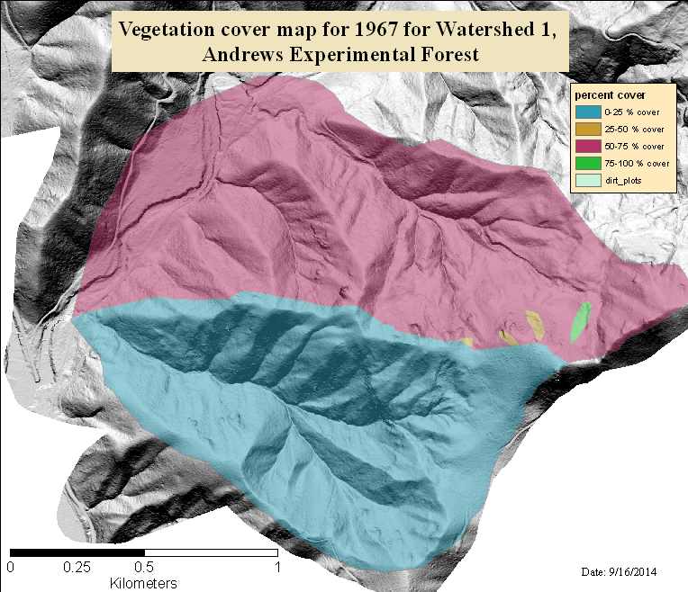
Cover maps were not made for the 1967 photos, the year after the harvest and burn were completed in WS 1, because these photos did not show significant vegetation cover in WS.
This layer shows the 0 percent cover in WS1, and estimates of percent cover in the area north, adjacent to WS1.
There are no credits for this item.
See data access policy at www.fsl.orst.edu/lter (especially the data use policy)
Extent
West | -122.259846 | East | -122.230255 |
North | 44.215814 | South | 44.198861 |
Maximum (zoomed in) | 1:5,000 |
Minimum (zoomed out) | 1:150,000,000 |
ground condition
While substantial efforts are made to ensure the accuracy of data and documentation, complete accuracy of data sets cannot be guaranteed. All data are made available "as is". The Andrews LTER shall not be liable for damages resulting from any use or misinterpretation of data sets.
Available on-line
See data access policy at www.fsl.orst.edu/lter (especially the data use policy)
Obtain information off of WWW site, call contact person for special requests.
polygon attribute table
esri
Internal feature number.
ESRI
Feature geometry.
ESRI
Area of feature in internal units squared.
ESRI
Perimeter of feature in internal units.
ESRI
internally generated unique whole number
esri
user defined unique number
esri
percent cover (aerial photo interpretation)
author thesis
Vegetation history classification for watersheds 1, 2, and 3 (1959-1990), Andrews Experimental Forest. Photos were interpreted for hydrologically relevant vegetation types (conifer, broadleaf, grasses and bare soil) and forest age class was determined for each year (1959, 1962, 1967, 1972, 1979, and 1990). Vegetation data for functional groups (conifer, evergreen broadleaf, deciduous broadleaf) was aggregated from species data available in TP73 for the long term vegetation plots in Watershed 1.
To document the history of vegetation classification for watersheds 1, 2, and 3, pre and post harvest.
ground condition
Available on-line
See data access policy at www.fsl.orst.edu/lter (especially the data use policy)
The accuracy of the aerial photo interpretation was assessed through comparison of the percent cover maps against the plot cover measurements. Some differences were expected between the mapped cover percentages and the plot measurement, because of the difference in the resolution of the mapped areas and the 2x2m plot size. The mapped areas were drawn with an expectation that there was significant heterogeneity in the vegetation cover within each map unit. These results are presented in Appendix B of thesis.
The 1972 herbaceous cover map agreed with the plot data for 45 plots, and in general overestimated herbaceous cover. The 1972 conifer and evergreen broadleaf cover map agreed with the plot data for 31 plots, and in general overestimated conifer and evergreen broadleaf cover. The 1972 deciduous broadleaf cover map agreed with the plot data for 58 plots, and in general underestimated deciduous cover. The 1979 conifer and evergreen broadleaf cover map agreed with the plot data for 35 plots, and in general overestimated conifer and evergreen broadleaf cover. The 1979 deciduous broadleaf cover map agreed with the plot data for 44 plots, and in general underestimated deciduous cover. The 1990 herbaceous cover map agreed with the plot data for 27 plots, and in general overestimated herbaceous cover. The 1990 evergreen broadleaf cover map agreed with the plot data for 18 plots, and in general overestimated evergreen broadleaf cover. The 1990 conifer cover map agreed with the plot data for 28 plots, and in general overestimated conifer cover. The 1990 deciduous broadleaf cover map agreed with the plot data for 34 plots. These map assessments were not used to adjust the cover map for two reasons. The resolution of the map units was quite a bit larger than the plot size, and there was no discernible spatial pattern in the plot data that could have been used to adjust the cover maps.
Metadata imported.
Metadata imported.
While substantial efforts are made to ensure the accuracy of data and documentation, complete accuracy of data sets cannot be guaranteed. All data are made available "as is". The Andrews LTER shall not be liable for damages resulting from any use or misinterpretation of data sets.
Obtain information off of WWW site, call contact person for special requests.