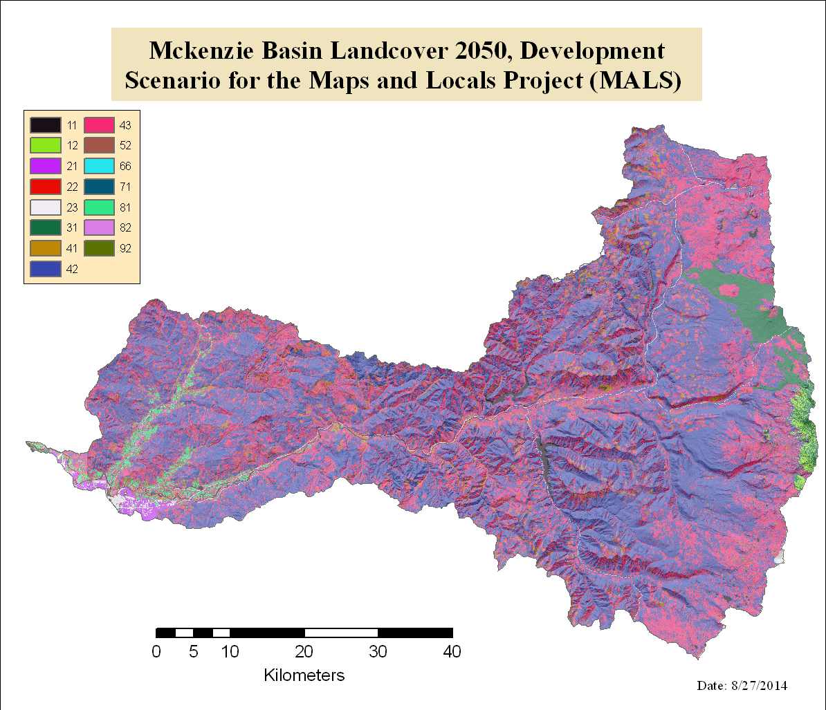
Mckenzie Basin Landcover 2050, Development Scenario for the Maps and Locals Project (MALS)

Raster Dataset
Thumbnail

Tags
Land Cover, HJ Andrews, MALS, PNW ERC


Summary

This dataset was developed for use in an analysis of landcover change in the McKenzie Basin for the Maps and Locals (MALS) project. A consistent classification was used across datasets to facilitate change detection. The more detailed original dataset should be used for all other applications (see http://www.fsl.orst.edu/pnwerc/wrb/access.html).

Description

Re-classified landcover data of the Mackenzie River Basin. Original data came from the Pacific Northwest Ecosystem Research Consortium Willamette Basin Future Scenarios 2050 Project Development Scenario for 2050 (see http://www.fsl.orst.edu/pnwerc/wrb/access.htmlfor more information on the original dataset). Class 1-2 were assigned to Low Intensity Residential, 3-4 to High Intensity Residential, 6-11 to Commercial/Industrial, 16 to Low Intensity Residential, 18-21 to Commercial/Industrial, 24 and 29 to Bare Rock/Sand/Clay, 32-33 to Open Water, 39 to Bare Rock/Sand/Clay, 40 to Ice/Snow, 42 to Bare Rock/Sand/Clay, 49 to Low Intensity Residential, 51-52 to Mixed Forest, 53 to Deciduous Forest, 54 to Mixed Forest, 55-62 to Evergreen Forest, 67-68 to Pasture/Hay, 72 to Emergent Herbaceous Wetlands, 73-79 to Row Crop/Orchard, 80-81 to Pasture/Hay, 82 to Row Crop/Orchard, 83 to Pasture/Hay, 84 to Row Crop/Orchard, 85 to Pasture/Hay, 86 to Grassland/Herbaceous, 87 to Shrubland, 88 to Bare Rock/Sand/Clay, 89 to Emergent Herbaceous Wetland, 90 to Row Crop/Orchard, 91 to Woody Wetland, 92-93 to Row Crop/Orchard, 95 to Evergreen, 98 to Deciduous Forest, 101 to Woody Wetland.

Credits

Developed for Dr. Hannah Gosnell, Oregon State University, College of Earth, Oceanic, and Atmospheric Science with data from PNW ERC.

Use limitations

None

Extent

West  -123.643455    East  -121.465766
North  45.148605    South  43.612508

Scale Range
Maximum (zoomed in)  1:5,000
Minimum (zoomed out)  1:500,000

ArcGIS Metadata 

Topics and Keywords 

Themes or categories of the resource  environment, imageryBaseMapsEarthCover, society


*Content type  Downloadable Data
Export to FGDC CSDGM XML format as Resource Description No

Place keywords  Andrews Experimental Forest (HJA), Western Oregon Cascades, Willamette National, Forest, McKenzie River Watershed, Oregon

Thesaurus
Title Andrews LTER Preferred Place Keyword List


Theme keywords  Attitudes/perceptions, change detection, human dimension, human-natural, systems, land cover, land ownership, landscape modeling, mapping, vegetation, modeling

Thesaurus
Title Andrews LTER Preferred Keyword List


Citation 

Title Mckenzie Basin Landcover 2050, Development Scenario for the Maps and Locals Project (MALS)
Creation date 2009-04-20 00:00:00
Publication date 2013-08-23 00:00:00


Presentation formats  digital map


Other citation details ss00205


Citation Contacts 

Responsible party
Individual's name Myrica McCune
Organization's name Oregon State University
Contact's position GIS Technician
Contact's role  originator


Contact information
Phone
Voice 5412315927
Fax none

Address
Delivery point Institute For Natural Resources, 210 Strand Ag, Oregon State University
City Corvallis
Administrative area OR
Country US
e-mail addressmyrica.mccune@oregonstate.edu


Responsible party
Individual's name Theresa Valentine
Organization's name Corvallis Forest Science Laboratory
Contact's position Spatial Information Manager
Contact's role  point of contact


Contact information
Phone
Voice 541-750-7333
Fax 541-758-7760

Address
Type both
Delivery point 3200 SW Jefferson Way
City Corvallis
Administrative area Oregon
Postal code 97332
Country US
e-mail addresstvalentine@fs.fed.us or theresa.valentine@orst.edu

Hours of service m-f 8:00am-4:00pm


Resource Details 

Dataset languages  English (UNITED STATES)
Dataset character set  utf8 - 8 bit UCS Transfer Format


Status  completed
Spatial representation type  grid


Spatial resolution
Dataset's scale
Scale denominator 150000

Ground sample distance
Precision of spatial data 30 m (meter)


Processing environment Microsoft Windows 7 Version 6.1 (Build 7601) Service Pack 1; Esri ArcGIS 10.1.0.3035


Credits
Developed for Dr. Hannah Gosnell, Oregon State University, College of Earth,
            Oceanic, and Atmospheric Science with data from PNW ERC.
ArcGIS item properties
*Name mals_devel50
*Location file://C:\hjandrews\newdata\mals\MALS_with_metadata\MALS_with_metadata\mals_devel50
*Access protocol Local Area Network

Extents 

Extent
Description
50 years out
Geographic extent
Bounding rectangle
Extent type  Extent used for searching
West longitude -123.643455
East longitude -121.465766
North latitude 45.148605
South latitude 43.612508
Extent contains the resource Yes

Temporal extent
Date and time 2050-01-01 00:00:00

Extent in the item's coordinate system
*West longitude -2152635.000000
*East longitude -2012115.000000
*South latitude 2600715.000000
*North latitude 2738475.000000
*Extent contains the resource Yes

Resource Points of Contact 

Point of contact
Individual's name Myrica McCune
Organization's name Oregon State University
Contact's position GIS Technician
Contact's role  originator


Contact information
Phone
Voice 5412315927
Fax none

Address
Type
Delivery point Institute For Natural Resources, 210 Strand Ag, Oregon State University
City Corvallis
Administrative area OR
Country US
e-mail addressmyrica.mccune@oregonstate.edu


Resource Maintenance 

Resource maintenance
Update frequency  not planned


Resource Constraints 

Constraints
Limitations of use
None

Spatial Reference 

ArcGIS coordinate system
*Type Projected
*Geographic coordinate reference GCS_North_American_1983
*Projection NAD_1983_Albers
*Coordinate reference details
Projected coordinate system
X origin -16901100
Y origin -6972200
XY scale 266467840.99085236
Z origin -100000
Z scale 10000
M origin -100000
M scale 10000
XY tolerance 0.001
Z tolerance 0.001
M tolerance 0.001
High precision true
Well-known text PROJCS["NAD_1983_Albers",GEOGCS["GCS_North_American_1983",DATUM["D_North_American_1983",SPHEROID["GRS_1980",6378137.0,298.257222101]],PRIMEM["Greenwich",0.0],UNIT["Degree",0.0174532925199433]],PROJECTION["Albers"],PARAMETER["False_Easting",0.0],PARAMETER["False_Northing",0.0],PARAMETER["Central_Meridian",-96.0],PARAMETER["Standard_Parallel_1",29.5],PARAMETER["Standard_Parallel_2",45.5],PARAMETER["Latitude_Of_Origin",23.0],UNIT["Meter",1.0]]

Reference system identifier
Value 0


Spatial Data Properties 

Georectified Grid
Number of dimensions 2


Axis dimensions properties
Dimension type  column (x-axis)
Dimension size 4684
Resolution  30.000000 Meter

Axis dimensions properties
Dimension type  row (y-axis)
Dimension size 4592
Resolution  30.000000 Meter

*Cell geometry  area
*Point in pixel  center


Transformation parameters are available Yes


Check points are available No


Corner points
Point -2152635.000000 2600715.000000
Point -2152635.000000 2738475.000000
Point -2012115.000000 2738475.000000
Point -2012115.000000 2600715.000000

Center point -2082375.000000 2669595.000000


ArcGIS Raster Properties
General Information
*Pixel depth 8
*Compression type RLE
*Number of bands 1
*Raster format GRID
*Source type continuous
*Pixel type unsigned integer
*No data value 0
*Has colormap No
*Has pyramids No


Spatial Data Content 

Image Description
*Type of information  physical measurement
Attribute described by cell values Land Cover Classification, Modeled


Band information
Description cons50
Maximum value 92.000000
Minimum value 11.000000
Number of bits per value 8


Triangulation has been performed No
Radiometric calibration is available No
Camera calibration is available No
Film distortion information is available No
Lens distortion information is available No


Data Quality 

Lineage 

Lineage statement
Original dataset source defined in description. Original raster was projected
                (snappng to NLCD grid), reclssified, and clipped to McKenzie basin boundary.
            

Distribution 

Distributor
Contact information
Individual's name Theresa Valentine
Organization's name Corvallis Forest Science Laboratory
Contact's position Spatial Information Manager
Contact's role  distributor


Contact information
Phone
Voice 541-750-7333
Fax 541-758-7760

Address
Type both
Delivery point 3200 SW Jefferson Way
City Corvallis
Administrative area Oregon
Postal code 97332
Country US
e-mail addresstvalentine@fs.fed.us or theresa.valentine@orst.edu

Hours of service m-f 8:00am-4:00pm


Available format
Name zip file with arc/info export file
Version 20130823


Transfer options
Units of distribution zip file


Online source
Locationhttp://andrewsforest.oregonstate.edu/data/studies/spatialdata/ss00205.zip
Access protocol zip file
Function performed  download


Distribution format
Name Raster Dataset
Version arcgis 10.1


Fields 

Details for object mals_devel50.vat 
*Type Table
*Row count 15
Definition
value attribute table
Definition source
esri


Field Rowid
 
*Alias Rowid
*Data type OID
*Width 4
*Precision 0
*Scale 0
Field description
Internal feature number.
Description source
Esri
Description of values Sequential unique whole numbers that are automatically generated.


Field VALUE
 
*Alias VALUE
*Data type Integer
*Width 4
*Precision 0
*Scale 0
Field description
reclassified land-cover
Description source
originator
List of values
Value 1-2
Description Low Intensity Residential
Enumerated domain value definition source originator


Value 3-4
Description High Intensity Residential
Enumerated domain value definition source originator


Value 6-11
Description Commercial/Industrial
Enumerated domain value definition source originator


Value 16
Description Low Intensity Residential
Enumerated domain value definition source originator


Value 18-21
Description Commercial/Industrial
Enumerated domain value definition source originator


Value 24
Description  Bare Rock/Sand/Clay
Enumerated domain value definition source originator


Value 29
Description  Bare Rock/Sand/Clay
Enumerated domain value definition source originator


Value 32-33
Description Open Water
Enumerated domain value definition source originator


Value 39
Description Bare Rock/Sand/Clay
Enumerated domain value definition source originator


Value 40
Description Ice/Snow
Enumerated domain value definition source originator


Value 42
Description Bare Rock/Sand/Clay
Enumerated domain value definition source originator


Value 49
Description Low Intensity Residential
Enumerated domain value definition source originator


Value 51-52
Description Mixed Forest
Enumerated domain value definition source originator


Value 53
Description Deciduous Forest
Enumerated domain value definition source originator


Value 54
Description Mixed Forest
Enumerated domain value definition source originator


Value 55-62
Description Evergreen Forest
Enumerated domain value definition source originator


Value 67-68
Description Pasture/Hay
Enumerated domain value definition source originator


Value 72
Description Emergent Herbaceous Wetlands
Enumerated domain value definition source originator


Value 73-79
Description Row Crop/Orchard
Enumerated domain value definition source originator


Value 80-81
Description Pasture/Hay
Enumerated domain value definition source originator


Value 82
Description Row Crop/Orchard
Enumerated domain value definition source originator


Value 83
Description Pasture/Hay
Enumerated domain value definition source originator


Value 84
Description Row Crop/Orchard
Enumerated domain value definition source originator


Value 85
Description Pasture/Hay
Enumerated domain value definition source originator


Value 86
Description Grassland/Herbaceous
Enumerated domain value definition source originator


Value 87
Description Shrubland
Enumerated domain value definition source originator


Value 88
Description Bare Rock/Sand/Clay
Enumerated domain value definition source originator


Value 89
Description Emergent Herbaceous Wetland
Enumerated domain value definition source originator


Value 90
Description Row Crop/Orchard
Enumerated domain value definition source originator


Value 91
Description Woody Wetland
Enumerated domain value definition source originator


Value 92-93
Description Row Crop/Orchard
Enumerated domain value definition source originator


Value 93
Description Evergreen Forest
Enumerated domain value definition source originator


Value 98
Description Deciduous Forest
Enumerated domain value definition source originator


Value 101
Description Woody Wetland
Enumerated domain value definition source originator


Field COUNT
 
*Alias COUNT
*Data type Integer
*Width 4
*Precision 0
*Scale 0
Field description
number of pixals of particular value
Description source
esri
Description of values computer generated


Metadata Details 

Metadata language English (UNITED STATES)
Metadata character set  utf8 - 8 bit UCS Transfer Format


Scope of the data described by the metadata  dataset
Scope name  dataset


Last update 2013-08-23


ArcGIS metadata properties
Metadata format ArcGIS 1.0
Standard or profile used to edit metadata FGDC


Last modified in ArcGIS for the item 2014-08-28 16:03:34


Automatic updates
Last update 2014-08-28 16:03:34


Metadata Contacts 

Metadata contact
Individual's name Myrica McCune
Organization's name Oregon State University
Contact's position GIS Technician
Contact's role  originator


Contact information
Phone
Voice 5412315927
Fax none

Address
Delivery point Institute For Natural Resources, 210 Strand Ag, Oregon State University
City Corvallis
Administrative area OR
Country US
e-mail addressmyrica.mccune@oregonstate.edu


Metadata contact
Individual's name Theresa Valentine
Organization's name Corvallis Forest Science Laboratory
Contact's position Spatial Information Manager
Contact's role  publisher


Contact information
Phone
Voice 541-750-7333
Fax 541-758-7760

Address
Type both
Delivery point 3200 SW Jefferson Way
City Corvallis
Administrative area Oregon
Postal code 97332
Country US
e-mail addresstvalentine@fs.fed.us or theresa.valentine@orst.edu

Hours of service m-f 8:00am-4:00pm


Thumbnail and Enclosures 

Thumbnail
Thumbnail type  JPG

FGDC Metadata (read-only) 

Entities and Attributes 

Detailed Description
Entity Type
Entity Type Labeldevel50.vat
Entity Type Definition
value attribute table
Entity Type Definition Sourceesri

Attribute
Attribute LabelRowid
Attribute Definition
Internal feature number.
Attribute Definition SourceEsri
Attribute Domain Values
Unrepresentable Domain
Sequential unique whole numbers that are automatically generated.

Attribute
Attribute LabelVALUE
Attribute Definition
reclassified land-cover
Attribute Definition Sourceoriginator
Attribute Domain Values
Enumerated Domain
Enumerated Domain Value1-2
Enumerated Domain Value Definition
Low Intensity Residential
Enumerated Domain Value Definition Source
originator
Enumerated Domain
Enumerated Domain Value3-4
Enumerated Domain Value Definition
High Intensity Residential
Enumerated Domain Value Definition Source
originator
Enumerated Domain
Enumerated Domain Value6-11
Enumerated Domain Value Definition
Commercial/Industrial
Enumerated Domain Value Definition Source
originator
Enumerated Domain
Enumerated Domain Value16
Enumerated Domain Value Definition
Low Intensity Residential
Enumerated Domain Value Definition Source
originator
Enumerated Domain
Enumerated Domain Value18-21
Enumerated Domain Value Definition
Commercial/Industrial
Enumerated Domain Value Definition Source
originator
Enumerated Domain
Enumerated Domain Value24
Enumerated Domain Value Definition
Bare Rock/Sand/Clay
Enumerated Domain Value Definition Source
originator
Enumerated Domain
Enumerated Domain Value29
Enumerated Domain Value Definition
Bare Rock/Sand/Clay
Enumerated Domain Value Definition Source
originator
Enumerated Domain
Enumerated Domain Value32-33
Enumerated Domain Value Definition
Open Water
Enumerated Domain Value Definition Source
originator
Enumerated Domain
Enumerated Domain Value39
Enumerated Domain Value Definition
Bare Rock/Sand/Clay
Enumerated Domain Value Definition Source
originator
Enumerated Domain
Enumerated Domain Value40
Enumerated Domain Value Definition
Ice/Snow
Enumerated Domain Value Definition Source
originator
Enumerated Domain
Enumerated Domain Value42
Enumerated Domain Value Definition
Bare Rock/Sand/Clay
Enumerated Domain Value Definition Source
originator
Enumerated Domain
Enumerated Domain Value49
Enumerated Domain Value Definition
Low Intensity Residential
Enumerated Domain Value Definition Source
originator
Enumerated Domain
Enumerated Domain Value51-52
Enumerated Domain Value Definition
Mixed Forest
Enumerated Domain Value Definition Source
originator
Enumerated Domain
Enumerated Domain Value53
Enumerated Domain Value Definition
Deciduous Forest
Enumerated Domain Value Definition Source
originator
Enumerated Domain
Enumerated Domain Value54
Enumerated Domain Value Definition
Mixed Forest
Enumerated Domain Value Definition Source
originator
Enumerated Domain
Enumerated Domain Value55-62
Enumerated Domain Value Definition
Evergreen Forest
Enumerated Domain Value Definition Source
originator
Enumerated Domain
Enumerated Domain Value67-68
Enumerated Domain Value Definition
Pasture/Hay
Enumerated Domain Value Definition Source
originator
Enumerated Domain
Enumerated Domain Value72
Enumerated Domain Value Definition
Emergent Herbaceous Wetlands
Enumerated Domain Value Definition Source
originator
Enumerated Domain
Enumerated Domain Value73-79
Enumerated Domain Value Definition
Row Crop/Orchard
Enumerated Domain Value Definition Source
originator
Enumerated Domain
Enumerated Domain Value80-81
Enumerated Domain Value Definition
Pasture/Hay
Enumerated Domain Value Definition Source
originator
Enumerated Domain
Enumerated Domain Value82
Enumerated Domain Value Definition
Row Crop/Orchard
Enumerated Domain Value Definition Source
originator
Enumerated Domain
Enumerated Domain Value83
Enumerated Domain Value Definition
Pasture/Hay
Enumerated Domain Value Definition Source
originator
Enumerated Domain
Enumerated Domain Value84
Enumerated Domain Value Definition
Row Crop/Orchard
Enumerated Domain Value Definition Source
originator
Enumerated Domain
Enumerated Domain Value85
Enumerated Domain Value Definition
Pasture/Hay
Enumerated Domain Value Definition Source
originator
Enumerated Domain
Enumerated Domain Value86
Enumerated Domain Value Definition
Grassland/Herbaceous
Enumerated Domain Value Definition Source
originator
Enumerated Domain
Enumerated Domain Value87
Enumerated Domain Value Definition
Shrubland
Enumerated Domain Value Definition Source
originator
Enumerated Domain
Enumerated Domain Value88
Enumerated Domain Value Definition
Bare Rock/Sand/Clay
Enumerated Domain Value Definition Source
originator
Enumerated Domain
Enumerated Domain Value89
Enumerated Domain Value Definition
Emergent Herbaceous Wetland
Enumerated Domain Value Definition Source
originator
Enumerated Domain
Enumerated Domain Value90
Enumerated Domain Value Definition
Row Crop/Orchard
Enumerated Domain Value Definition Source
originator
Enumerated Domain
Enumerated Domain Value91
Enumerated Domain Value Definition
Woody Wetland
Enumerated Domain Value Definition Source
originator
Enumerated Domain
Enumerated Domain Value92-93
Enumerated Domain Value Definition
Row Crop/Orchard
Enumerated Domain Value Definition Source
originator
Enumerated Domain
Enumerated Domain Value93
Enumerated Domain Value Definition
Evergreen Forest
Enumerated Domain Value Definition Source
originator
Enumerated Domain
Enumerated Domain Value98
Enumerated Domain Value Definition
Deciduous Forest
Enumerated Domain Value Definition Source
originator
Enumerated Domain
Enumerated Domain Value101
Enumerated Domain Value Definition
Woody Wetland
Enumerated Domain Value Definition Source
originator

Attribute
Attribute LabelCOUNT
Attribute Definition
number of pixals of particular value
Attribute Definition Sourceesri
Attribute Domain Values
Unrepresentable Domain
computer generated