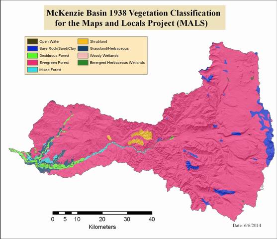
McKenzie Basin 1938 Vegetation Classification for the Maps and Locals Project (MALS)
zip file with arc/info export file

Tags
Land Cover, HJ Andrews, MALS,
GLO
This dataset was developed for use in an analysis of landcover change in the McKenzie Basin for the Maps and Locals (MALS) project. A consistent classification was used across datasets to facilitate change detection. The more detailed original dataset should be used for all other applications (see http://www.pdx.edu/pnwlamp/glo-based-historical-mapping-in-the-pacific-northwest). There were no developed classes in the original dataset, so users of the data need to be aware that those classes are missing from the raster because of source data limitations.
Re-classified landcover data of the McKenzie River Basin. Original data came from the Historical Vegetation 1938 map developed from the General Land Office survey by the Oregon Biodiversity Information Center (see http://www.pdx.edu/pnwlamp/glo-based-historical-mapping-in-the-pacific-northwestfor more information on the original dataset). The classes represent: 11= Open Water, 31= Bare Rock/Sand/Clay, 41= Deciduous Forest, 42= Evergreen Forest, 43= Mixed Forest, 51= Shrubland, 71= Grassland/Herbaceous, 91= Woody Wetlands, 92= Emergent Herbaceous Wetlands. There were no developed classes in the original dataset, so users of the data need to be aware that those classes are missing from the raster because of source data limitations.
Developed for Dr. Hannah Gosnell, Oregon State University, College of Earth, Oceanic, and Atmospheric Science with data from ORBIC
None
Extent
West -123.643455 East -121.465766 North 45.148605 South 43.612508
Maximum (zoomed in) 1:5,000 Minimum (zoomed out) 1:500,000