Shapefile
Tags
Western Cascades, Oregon, HJ Andrews
Experimental Forest, soil classification, soil
To provide information on soil classification, topography and physical properties of soils in the H J Andrews Exp. Forest
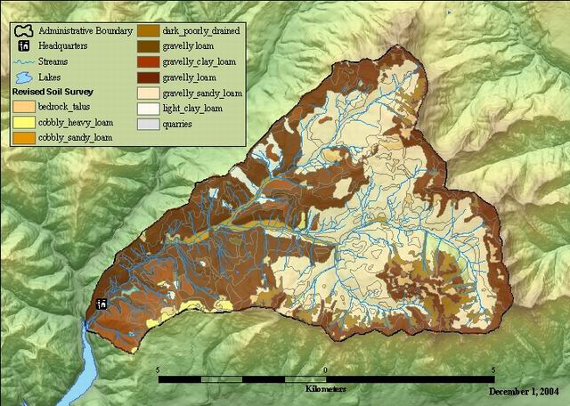
Soils map of the H J Andrews Exp Forest modified from 1964 soil survey. Joel Norgren and Ted Dyrness collected additional field data in 1993 and 1994. Joel Nordgen revised the 1964 soils polygon based on these additional data. Ken Vance-Borland revised the original GIS soils layer based on Joel's interpretation, elevation contours, and the stream network. Polygon attributes were not changed.
There are no credits for this item.
While substantial efforts are made to ensure the accuracy of data and documentation, complete accuracy of data sets cannot be guaranteed. All data are made available "as is". The Andrews LTER shall not be liable for damages resulting from any use or misinterpretation of data sets.
Extent
West | -122.261523 | East | -122.100705 |
North | 44.282002 | South | 44.197820 |
Maximum (zoomed in) | 1:5,000 |
Minimum (zoomed out) | 1:150,000,000 |
publication date
Access constraints: Available on-line
Use constraints: See data access policy at www.fsl.orst.edu/lter/data.fr.htm (especially the data use policy)
While substantial efforts are made to ensure the accuracy of data and documentation, complete accuracy of data sets cannot be guaranteed. All data are made available "as is". The Andrews LTER shall not be liable for damages resulting from any use or misinterpretation of data sets.
Obtain information off of WWW site, call contact person for special requests.
Call contact person for instructions and costs.
polgyon features
FSL metadata document
Internal feature number.
ESRI
Feature geometry.
ESRI
area of polygons in square meters
FSL metadata document
perimeter of polygon in meters
FSL metadata document
internal feature number, carry-over from coverage format
FSL metadata document
user defined feature number, carry-over from coverage format
FSL metadata document
combined soil series and slope codes. First digit represent soil source, third digit is slope class. The first two digits are also represented within the MAP_UNIT code.
FSL metadata document
soils series names
FSL metadata document
Soil Texture Names for the DCODE attribute
FSL metadata document
texture code
FSL metadata document
slope steepness codes
FSL metadata document
soild depth codes
FSL metadata document
landform description/type.
FSL metadata document
soil series+slope+landform. The mapping unit symbols are int he following categories: a one digit number (4); a two digit number with a capital letter (12G); or a two digit number with a capital letter and a lower case letter (41Mt). The number signifies the soil series or miscellanious land type; the capital letter the slope class; and the lower case letter the landform The numbers reflect soil development. All numbers ending in zero are miscellaneous land types and should not be considered in the following discussion. The first (left) digit indicates the soil parent material as follows: 0 - alluvium 1 - glacial drift 2 - residuum/colluvium from basalt 4 - residuum/colluvium from greenish breccia 5 - residuum/colluvium from reddish breccia The capital letter in the symbol is the slope class. Slopes are classed as follows: G - gentle slope (0 - 30% slope) M - moderate slope (30 - 60% slope) V - steep slope (60+% slope) The lower case letter was added where a landform phase would materially increase the usefulness and significance of the soil map. The following symbols and landforms have been used: d - dissected slope l - landflow r - ridge t - toe slope u - uneven slope
Soil Survey Report of the HJ Andrews Experimental Forest
soil source codes
FSL metadata document
soil series code
FSL Metadata Document
slope code
FSL Metadata Document
Soil survey (1964, revised in 1994), Andrews Experimental Forest
To provide information on soil classification, topography and physical properties of soils in the H J Andrews Exp. Forest
publication date
Available on-line
See data access policy at www.fsl.orst.edu/lter/data.fr.htm (especially the data use policy)
Digitized from a 1964 map. Revised from additional data collected by Nordgen and Dyrness in 1994.
Dataset copied.
Dataset copied.
While substantial efforts are made to ensure the accuracy of data and documentation, complete accuracy of data sets cannot be guaranteed. All data are made available "as is". The Andrews LTER shall not be liable for damages resulting from any use or misinterpretation of data sets.
Local area network
Obtain information off of WWW site, call contact person for special requests.