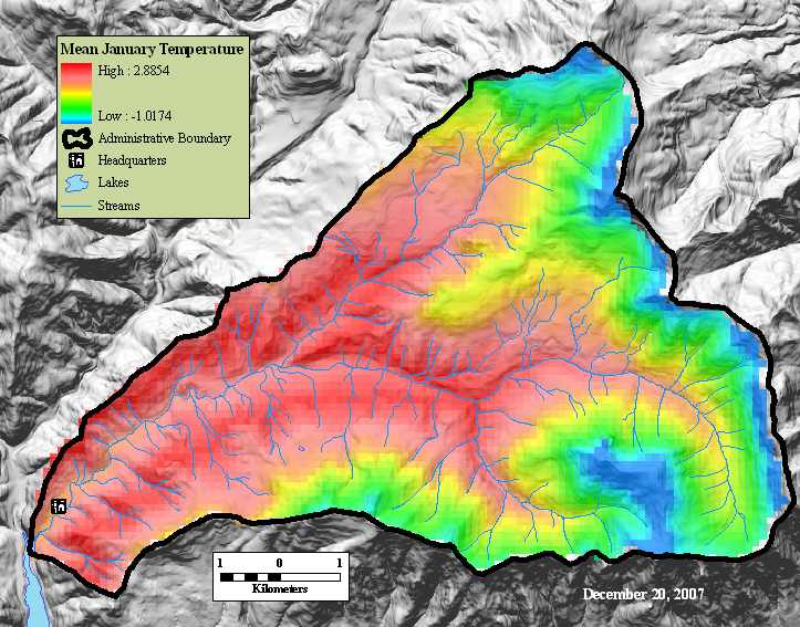
Mean January temperature (1980-1990)
Metadata:
- Identification_Information:
-
- Citation:
-
- Citation_Information:
-
- Originator: Lynn Rosentrater
- Publication_Date: 1997
- Title: Mean January temperature (1980-1990)
- Edition: 1
- Geospatial_Data_Presentation_Form: raster digital data
- Publication_Information:
-
- Publication_Place: Corvallis, OR
- Publisher: Forest Science Data Bank
- Other_Citation_Details:
-
ms02806
ms001
t:\gis\oregon\willamette\hja27\test1\temperature\tmaxann2
- Online_Linkage: <http://www.fsl.orst.edu/lter/data/spatialcatalog.cfm?topnav=160>
- Description:
-
- Abstract:
-
Temperature (deg C) maps (mean,max,min) for each month and annual
(time period 1981-1990) were developed by Lynn Rosentrater for her master's thesis. Data
came from the Andrews thermograph network.
- Purpose:
-
To help describe and analyze the natural variability of monthly and seasonal temperature regimes with the H. J. Andrews Experimental Forest.
- Time_Period_of_Content:
-
- Time_Period_Information:
-
- Range_of_Dates/Times:
-
- Beginning_Date: 1980
- Ending_Date: 1990
- Currentness_Reference: ground condition
- Status:
-
- Progress: Complete
- Maintenance_and_Update_Frequency: As needed
- Spatial_Domain:
-
- Bounding_Coordinates:
-
- West_Bounding_Coordinate: -122.269664
- East_Bounding_Coordinate: -122.096305
- North_Bounding_Coordinate: 44.286129
- South_Bounding_Coordinate: 44.192382
- Keywords:
-
- Theme:
-
- Theme_Keyword_Thesaurus: Andrews Forest LTER Thesaurus
- Theme_Keyword: termperature
- Theme_Keyword: climate data
- Theme_Keyword: climate/meteorology
- Theme_Keyword: climate modeling
- Theme_Keyword: mapping
- Theme_Keyword: meteorological measurements
- Place:
-
- Place_Keyword: Oregon
- Place_Keyword: Willamette Basin
- Place_Keyword: Blue River Watershed
- Place_Keyword: HJ Andrews Experimental Forest
- Place_Keyword: central meteorological station
- Place_Keyword: high 15 meteorlogical station
- Place_Keyword: primary meteorlogical station
- Place_Keyword: vanilla leaf meteorological station
- Access_Constraints: Available on-line
- Use_Constraints:
-
See data access policy at www.fsl.orst.edu/lter (especially the data use policy)
- Point_of_Contact:
-
- Contact_Information:
-
- Contact_Person_Primary:
-
- Contact_Person: Theresa Valentine
- Contact_Organization: Corvallis Forest Science Laboratory
- Contact_Position: Spatial Information Manager
- Contact_Address:
-
- Address_Type: mailing and physical address
- Address: 3200 SW Jefferson Way
- City: Corvallis
- State_or_Province: Oregon
- Postal_Code: 97332
- Country: USA
- Contact_Voice_Telephone: 541-750-7333
- Contact_Facsimile_Telephone: 541-750-7760
- Contact_Electronic_Mail_Address: tvalentine@fs.fed.us or theresa.valentine@orst.edu
- Hours_of_Service: m-f 0800-1630
- Security_Information:
-
- Security_Classification: Unclassified
- Native_Data_Set_Environment:
-
Microsoft Windows XP Version 5.1 (Build 2600) Service Pack 2; ESRI ArcCatalog 9.2.2.1350
- Cross_Reference:
-
- Citation_Information:
-
- Originator: Lynn D. Rosentrater
- Publication_Date: 1997
- Title:
-
The thermal climate of the H. J. Andrews Experimental Forest, Oregon
- Publication_Information:
-
- Publication_Place: Eugene, Oregon
- Publisher: University of Oregon
- Other_Citation_Details:
-
pub # 2383
thesis
- Online_Linkage:
-
<http://www.fsl.orst.edu/lter/search/Show_Catalog_Item.cfm?Catalog_id=1375&Catalog_type=Publication&topnav=82>
- Data_Quality_Information:
-
- Attribute_Accuracy:
-
- Attribute_Accuracy_Report: +_ 0.5 C accuracy for temperature (from thesis)
- Logical_Consistency_Report: Good.
- Completeness_Report:
-
Note that the following months do NOT have data due to
problems with the original surfer files:
Mean temperature: mar, dec
Max temperature: june, sept, oct
Min temperature: feb, may
- Lineage:
-
- Source_Information:
-
- Source_Scale_Denominator: 120 meter DEM
- Type_of_Source_Media: physical model
- Source_Contribution:
-
Temperature maps (mean,max,min) for each month and annual were
developed by Lynn Rosentrater for her master's thesis. Data
came from the Andrews thermograph network. Lynn developed
Surfer maps from which the ArcInfo Grids were created.
See Lynn's thesis for more information (Andrews pub #2383
- Process_Step:
-
- Process_Description:
-
Temperature maps (mean,max,min) for each month and annual were
developed by Lynn Rosentrater for her master's thesis. Data
came from the Andrews thermograph network. Lynn developed
Surfer maps from which the ArcInfo Grids were created.
See Lynn's thesis for more information. (HJ Andrews pub number 2383)
- Process_Step:
-
- Process_Description: Metadata imported.
- Source_Used_Citation_Abbreviation: J:\hja27\test1\temperature\tmaxann\metadata.xml
- Process_Step:
-
- Process_Description: Metadata imported.
- Source_Used_Citation_Abbreviation: Z:\test1\temperature\tmeanjan\metadata.xml
- Spatial_Data_Organization_Information:
-
- Direct_Spatial_Reference_Method: Raster
- Raster_Object_Information:
-
- Raster_Object_Type: Grid Cell
- Row_Count: 86
- Column_Count: 115
- Vertical_Count: 1
- Spatial_Reference_Information:
-
- Horizontal_Coordinate_System_Definition:
-
- Planar:
-
- Grid_Coordinate_System:
-
- Grid_Coordinate_System_Name: Universal Transverse Mercator
- Universal_Transverse_Mercator:
-
- UTM_Zone_Number: 10
- Transverse_Mercator:
-
- Scale_Factor_at_Central_Meridian: 0.999600
- Longitude_of_Central_Meridian: -123.000000
- Latitude_of_Projection_Origin: 0.000000
- False_Easting: 500000.000000
- False_Northing: 0.000000
- Planar_Coordinate_Information:
-
- Planar_Coordinate_Encoding_Method: row and column
- Coordinate_Representation:
-
- Abscissa_Resolution: 119.500000
- Ordinate_Resolution: 119.500000
- Planar_Distance_Units: meters
- Geodetic_Model:
-
- Horizontal_Datum_Name: North American Datum of 1927
- Ellipsoid_Name: Clarke 1866
- Semi-major_Axis: 6378206.400000
- Denominator_of_Flattening_Ratio: 294.978698
- Entity_and_Attribute_Information:
-
- Overview_Description:
-
- Entity_and_Attribute_Overview: Pixel value for each cell is in degrees Celsius.
- Distribution_Information:
-
- Distributor:
-
- Contact_Information:
-
- Contact_Person_Primary:
-
- Contact_Person: Theresa Valentine
- Contact_Organization: Corvallis Forest Science Laboratory
- Contact_Position: Spatial Information Manger
- Contact_Address:
-
- Address_Type: mailing and physical address
- Address: 3200 SW Jefferson Way
- City: Corvallis
- State_or_Province: OR
- Postal_Code: 97332
- Country: USA
- Contact_Voice_Telephone: 541-750-7333
- Contact_Facsimile_Telephone: 541-758-7760
- Contact_Electronic_Mail_Address: tvalentine@fs.fed.us or theresa.valentine@orst.edu
- Hours_of_Service: m-f 8:00am-4:30pm
- Resource_Description: Downloadable Data
- Distribution_Liability:
-
While substantial efforts are made to ensure the accuracy of data and documentation, complete accuracy of data sets cannot be guaranteed. All data are made available "as is". The Andrews LTER shall not be liable for damages resulting from any use or misinterpretation of data sets.
- Standard_Order_Process:
-
- Digital_Form:
-
- Digital_Transfer_Information:
-
- Format_Name: ARCE
- Transfer_Size: 0.100
- Digital_Transfer_Option:
-
- Online_Option:
-
- Computer_Contact_Information:
-
- Network_Address:
-
- Network_Resource_Name: T:\gis\oregon\willamette\hjandrews
- Fees: none
- Ordering_Instructions:
-
Obtain information off of WWW site, call contact person for special requests.
- Turnaround: as time permits
- Custom_Order_Process: Call contact person for instructions and costs.
- Metadata_Reference_Information:
-
- Metadata_Date: 20071105
- Metadata_Contact:
-
- Contact_Information:
-
- Contact_Person_Primary:
-
- Contact_Person: Theresa Valentine
- Contact_Organization: Corvallis Forest Science Laboratory
- Contact_Position: Spatial Information Manager
- Contact_Address:
-
- Address_Type: mailing and physical address
- Address: 3200 SW Jefferson Way
- City: Corvallis
- State_or_Province: Oregon
- Postal_Code: 97332
- Country: USA
- Contact_Voice_Telephone: 541-750-7333
- Contact_Facsimile_Telephone: 541-758-7760
- Contact_Electronic_Mail_Address: tvalentine@fs.fed.us or theresa.valentine@orst.edu
- Hours_of_Service: m-f 8:00am-4:00pm
- Metadata_Standard_Name: FGDC Content Standards for Digital Geospatial Metadata
- Metadata_Standard_Version: FGDC-STD-001-1998
- Metadata_Time_Convention: local time
- Metadata_Security_Information:
-
- Metadata_Security_Classification: Unclassified
- Metadata_Extensions:
-
- Online_Linkage: <http://www.esri.com/metadata/esriprof80.html>
- Profile_Name: ESRI Metadata Profile
Generated by mp version 2.8.6 on Mon Nov 05 09:57:41 2007