Mean June monthly precipitation(1980-1989)

Raster Dataset
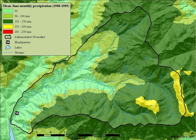
Thumbnail

Tags
climate, HJ Andrews, precipitation, meterological measurements, Willamette Basin, Oregon


Summary

Display and/or analyses requiring spatially distributed monthly or annual precipitation for the climatological period 1980-89.

Description

These files are spatially gridded precipitation of average monthly and annual precipitation for the climatological period 1980-89. Distribution of the point measurements to a spatial grid was accomplished using the PRISM model, developed by Chris Daly of PRISM Services/Oregon State University. Care should be taken in estimating precipitation values at any single point on the map. Precipitation estimated for each grid cell is an average over the entire area of that cell; thus, point precipitation can be estimated at a spatial precision no better than half the resolution of a cell. For example, the Oregon precipitation data was distributed at a resolution of approximately 4km. Therefore, point precipitation can be estimated at a spatial precision no better than 2km. However, the overall distribution of precipitation features is thought to be accurate. For further information, the online PRISM homepage can be found at <URL:http://prism.oregonstate.edu>. There are many methods of interpolating precipitation from monitoring stations to grid points. Some provide estimates of acceptable accuracy in flat terrain, but few have been able to adequately explain the extreme, complex variations in precipitation that occur in mountainous regions. Significant progress in this area has been achieved through the development of PRISM (Parameter-elevation Regressions on Independent Slopes Model). PRISM is an analytical model that uses point data and a digital elevation model (DEM) to generate gridded estimates of monthly and annual precipitation (as well as other climatic parameters). PRISM is well suited to regions with mountainous terrain, because it incorporates a conceptual framework that addresses the spatial scale and pattern of orographic precipitation.

Credits

Chris Daly

Use limitations

See data access policy at www.fsl.orst.edu/lter/data (especialy the data use policy)

Extent

West  -122.275687    East  -122.086322
North  44.298342    South  44.187168

Scale Range
Maximum (zoomed in)  1:5,000
Minimum (zoomed out)  1:150,000,000

ArcGIS Metadata 

Topics and Keywords 

Themes or categories of the resource  climatologyMeteorologyAtmosphere


*Content type  Downloadable Data


Place keywords  HJ Andrews, Willamette Basin, Oregon

Theme keywords  climate, precipitation, meterological measurements

Thesaurus
Title Andrews Forest LTER Thesaurus


Citation 

Title Mean June monthly precipitation(1980-1989)
Publication date 1995-01-01


Edition 1


Presentation formats* digital map


Collection title www.ocs.orst.edu/prism/prism_new.html


Other citation details
ms02706.zip 


Citation Contacts 

Responsible party
Individual's name Chris Daly
Organization's name PRISM Climate Group, Northwest Alliance for Computational Science and Engineering
Contact's position Director
Contact's role  originator


Contact information
Phone
Voice 541-737-2531

Address
Type both
Delivery point 2000 Kelley Engineering Center
City Corvallis
Administrative area OR
Postal code 97331
Country US
e-mail addressdaly@nacse.org


Resource Details 

Dataset languages  English (UNITED STATES)
Dataset character set  utf8 - 8 bit UCS Transfer Format


Status  completed
Spatial representation type* grid


*Processing environment Microsoft Windows 7 Version 6.1 (Build 7601) Service Pack 1; Esri ArcGIS 10.2.2.3552


Credits
Chris Daly

ArcGIS item properties
*Name hja6_83
*Location file://J:\hja83\daly2\hja6_83
*Access protocol Local Area Network

Extents 

Extent
Description
ground condition

Temporal extent
Date and time 1980-01-01 00:00:00

Temporal extent
Date and time 1989-01-01

Extent
Geographic extent
Bounding rectangle
Extent type  Extent used for searching
*West longitude -122.275687
*East longitude -122.086322
*North latitude 44.298342
*South latitude 44.187168
*Extent contains the resource Yes

Extent in the item's coordinate system
*West longitude 557887.025958
*East longitude 572887.025958
*South latitude 4893065.880327
*North latitude 4905265.880327
*Extent contains the resource Yes

Resource Points of Contact 

Point of contact
Individual's name Chris Daly
Organization's name PRISM Climate Group, Northwest Alliance for Computational Science and Engineering
Contact's position Director
Contact's role  point of contact


Contact information
Phone
Voice 541-737-2531

Address
Type both
Delivery point 2000 Kelley Engineering Center
City Corvallis
Administrative area OR
Postal code 97331
Country US
e-mail addressdaly@nacse.org


Resource Maintenance 

Resource maintenance
Update frequency  as needed


Resource Constraints 

Legal constraints
Limitations of use
While substantial efforts are made to ensure the accuracy of data and documentation, complete accuracy of data sets cannot be guaranteed. All data are made available "as is". The Andrews LTER shall not be liable for damages resulting from any use or misinterpretation of data sets.

Other constraints
Available on-line

Security constraints
Classification  unclassified


Constraints
Limitations of use

See data access policy at www.fsl.orst.edu/lter/data (especialy the data use policy)


Spatial Reference 

ArcGIS coordinate system
*Type Projected
*Geographic coordinate reference GCS_North_American_1983
*Projection NAD_1983_UTM_Zone_10N
*Coordinate reference details
Projected coordinate system
Well-known identifier 26910
X origin -5120900
Y origin -9998100
XY scale 450445547.3910538
Z origin -100000
Z scale 10000
M origin -100000
M scale 10000
XY tolerance 0.001
Z tolerance 0.001
M tolerance 0.001
High precision true
Latest well-known identifier 26910
Well-known text PROJCS["NAD_1983_UTM_Zone_10N",GEOGCS["GCS_North_American_1983",DATUM["D_North_American_1983",SPHEROID["GRS_1980",6378137.0,298.257222101]],PRIMEM["Greenwich",0.0],UNIT["Degree",0.0174532925199433]],PROJECTION["Transverse_Mercator"],PARAMETER["False_Easting",500000.0],PARAMETER["False_Northing",0.0],PARAMETER["Central_Meridian",-123.0],PARAMETER["Scale_Factor",0.9996],PARAMETER["Latitude_Of_Origin",0.0],UNIT["Meter",1.0],AUTHORITY["EPSG",26910]]

Reference system identifier
*Value 26910
*Codespace EPSG
*Version 8.2.6


Spatial Data Properties 

Georectified Grid
*Number of dimensions 2


Axis dimensions properties
Dimension type  column (x-axis)
*Dimension size 150
*Resolution  100.000000 m (meter)

Axis dimensions properties
Dimension type  row (y-axis)
*Dimension size 122
*Resolution  100.000000 m (meter)

*Cell geometry  area
*Point in pixel  center


*Transformation parameters are available Yes


*Check points are available No


Corner points
*Point 557887.025958 4893065.880327
*Point 557887.025958 4905265.880327
*Point 572887.025958 4905265.880327
*Point 572887.025958 4893065.880327

*Center point 565387.025958 4899165.880327


ArcGIS Raster Properties
General Information
*Pixel depth 16
*Compression type RLE
*Number of bands 1
*Raster format GRID
*Source type continuous
*Pixel type signed integer
*No data value -32768
*Has colormap No
*Has pyramids Yes


Spatial Data Content 

Image Description
*Type of information  physical measurement
Attribute described by cell values mean June monthly precipitation (1980-1989)


Band information
*Description Band_1
*Maximum value 167.000000
*Minimum value -9.000000
*Number of bits per value 16


Triangulation has been performed No
Radiometric calibration is available No
Camera calibration is available No
Film distortion information is available No
Lens distortion information is available No


Data Quality 

Scope of quality information
Resource level  dataset


Data quality report - Conceptual consistency
Measure description
All data were based on the same averaging period (1980-1989). Similar quality assurance procedures were used with all input data sets.


Data quality report - Quantitative attribute accuracy
Measure description
Care should be taken in estimating precipitation values at any single point on the map. Precipitation estimated for each grid cell is an average over the entire area of that cell; thus, point precipitation can be estimated at a spatial precision no better than half the resolution of a cell. For example, the Oregon precipitation data was distributed at a resolution of approximately 4km. Therefore, point precipitation can be estimated at a spatial precision no better than 2km. However, the overall distribution of precipitation features is thought to be accurate.


Lineage 

Process step
When the process occurred 1999-06-07 00:00:00
Description
It is beyond the scope of this metadata to document the processes involved in generating spatially gridded precipitation using the PRISM model. However, the processes are documented in numerous conference proceedings and journal articles. The references can be found online at <URL:http://www.ocs.orst.edu/prism/prism_new.html>.


Process contact
Individual's name Hazel Hammond
Organization's name Corvallis Forest Science Laboratory
Contact's position Programmer
Contact's role  processor


Process step
When the process occurred 2015-11-23 00:00:00
Description
project to NAD83 per USFS standard

Rationale
per USFS standard


Process contact
Individual's name Theresa Valentine
Organization's name Corvallis Forest Science Laboratory
Contact's position Spatial Information Manager
Contact's role  processor


Contact information
Phone
Voice 541-750-7333
Fax 541-758-7760

Address
Type both
Delivery point 3200 SW Jefferson Way
City Corvallis
Administrative area Oregon
Postal code 97332
Country US
e-mail addresstvalentine@fs.fed.us or theresa.valentine@orst.edu

Hours of service
m-f 8:00am-4:00pm


Source data
Description
Chris Daly


Source medium name  online link
Resolution of the source data
Scale denominator 0

Source citation
Title HJA Meterological Network Stations


Presentation formats  digital map
FGDC geospatial presentation format  vector digital data


Other citation details
ms026


Responsible party
Organization's name Donald Henshaw
Contact's role  originator


Resource location online
Locationhttp://www.fsl.orst.edu/lter/data/spatialcatalog.cfm?topnav=160


Extent of the source data
Description
ground condition

Temporal extent
Beginning date
Indeterminate date 01/1980
Ending date
Indeterminate date 12/1989


Distribution 

Distributor
Contact information
Individual's name Theresa Valentine
Organization's name USDA Forest Service, Corvallis Forest Science Laboratory
Contact's position Spatial Information Manager
Contact's role  distributor


Contact information
Phone
Voice 541-750-7333
Fax 541-750-7760

Address
Type both
Delivery point 3200 SW Jefferson Way
City Corvallis
Administrative area OR
Postal code 97331
Country US
e-mail addresstvalentine@fs.fed.us

Hours of service
m-f 0800-1630

Contact instructions
e-mail or voice mail


Available format
File decompression technique no compression applied
Name esri .e00 file within a zip file


Ordering process
Terms and fees none
Instructions
Obtain information off of WWW site, call contact person for special requests.


Transfer options
Online source
Location  http://andrewsforest.oregonstate.edu/data/studies/spatialdata/ms02706.zip
Access protocol zip file
Function performed  download


Distribution format
Version ArcGIS 10.2
*Name Raster Dataset


Fields 

Details for object hja6_83.vat 
Type raster
*Row count 102
Definition
raster data set

Definition source
dataset


Field Rowid
 
*Alias Rowid
*Data type OID
*Width 4
*Precision 0
*Scale 0
*Field description
Internal feature number.

*Description source
ESRI

*Description of values
Sequential unique whole numbers that are automatically generated.


Field VALUE
 
*Alias VALUE
*Data type Integer
*Width 4
*Precision 0
*Scale 0
Field description
 mean monthly precipitation in millimeters

Description source
PRISM website

Description of values
number generated by computer model output.


Field COUNT
 
*Alias COUNT
*Data type Integer
*Width 4
*Precision 0
*Scale 0
Field description
cell count per value

Description source
esri documentation

Description of values
number generated by computer program, based on number of cells with a particular value.


References 

Aggregate Information
Association type  cross reference


Aggregate resource name
Title PRISM homepage
Creation date 2015-01-01 00:00:00
Publication date 2015-09-10 00:00:00


Responsible party
Organization's name Chris Daly, PRISM Services, OSU
Contact's role  originator


Resource location online
Locationhttp://prism.oregonstate.edu


Metadata Details 

Metadata language English (UNITED STATES)
Metadata character set  utf8 - 8 bit UCS Transfer Format


Scope of the data described by the metadata  dataset
Scope name* dataset


*Last update 2015-11-23


ArcGIS metadata properties
Metadata format ArcGIS 1.0
Standard or profile used to edit metadata FGDC


Created in ArcGIS for the item 2007-09-06 12:12:50
Last modified in ArcGIS for the item 2015-11-23 14:41:20


Automatic updates
Have been performed Yes
Last update 2015-11-23 14:38:15


Metadata Contacts 

Metadata contact
Individual's name Theresa Valentine
Organization's name USDA Forest Service, Corvallis Forest Science Laboratory
Contact's position Spatial Data Manager
Contact's role  point of contact


Contact information
Phone
Voice 541-750-7333
Fax m-f 0800-1630

Address
Type both
Delivery point 3200 SW Jefferson Way
City Corvallis
Administrative area OR
Postal code 97330
e-mail addresstvalentine@fs.fed.us


Metadata Maintenance 

Maintenance
Update frequency  as needed


Thumbnail and Enclosures 

Thumbnail
Thumbnail type  JPG

FGDC Metadata (read-only) 

Entities and Attributes 

Detailed Description
Entity Type
Entity Type Labelhja6_83
Entity Type Definition
raster data set
Entity Type Definition Sourcedataset

Attribute
Attribute LabelRowid
Attribute Definition
Internal feature number.
Attribute Definition SourceESRI
Attribute Domain Values
Unrepresentable Domain
Sequential unique whole numbers that are automatically generated.

Attribute
Attribute LabelVALUE
Attribute Definition
mean monthly precipitation in millimeters
Attribute Definition SourcePRISM website
Attribute Domain Values
Unrepresentable Domain
number generated by computer model output.

Attribute
Attribute LabelCOUNT
Attribute Definition
cell count per value
Attribute Definition Sourceesri documentation
Attribute Domain Values
Unrepresentable Domain
number generated by computer program, based on number of cells with a particular value.