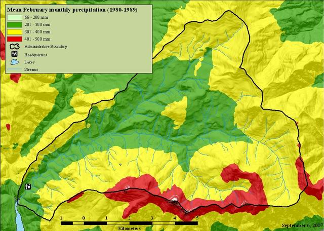
Mean February monthly precipitation (1980-1989)
Raster Dataset

Tags
climate,
HJ Andrews, precipitation, meterological measurements, Willamette Basin,
Oregon
Display and/or analyses requiring spatially distributed monthly or annual precipitation for the climatological period 1980-89.
These files are spatially gridded precipitation of average monthly and annual precipitation for the climatological period 1980-89. Distribution of the point measurements to a spatial grid was accomplished using the PRISM model, developed by Chris Daly of PRISM Services/Oregon State University. Care should be taken in estimating precipitation values at any single point on the map. Precipitation estimated for each grid cell is an average over the entire area of that cell; thus, point precipitation can be estimated at a spatial precision no better than half the resolution of a cell. For example, the Oregon precipitation data was distributed at a resolution of approximately 4km. Therefore, point precipitation can be estimated at a spatial precision no better than 2km. However, the overall distribution of precipitation features is thought to be accurate. For further information, the online PRISM homepage can be found at <URL:http://prism.oregonstate.edu>. There are many methods of interpolating precipitation from monitoring stations to grid points. Some provide estimates of acceptable accuracy in flat terrain, but few have been able to adequately explain the extreme, complex variations in precipitation that occur in mountainous regions. Significant progress in this area has been achieved through the development of PRISM (Parameter-elevation Regressions on Independent Slopes Model). PRISM is an analytical model that uses point data and a digital elevation model (DEM) to generate gridded estimates of monthly and annual precipitation (as well as other climatic parameters). PRISM is well suited to regions with mountainous terrain, because it incorporates a conceptual framework that addresses the spatial scale and pattern of orographic precipitation.
Chris Daly
See data access policy at www.fsl.orst.edu/lter/data (especialy the data use policy)
Extent
West -122.275687 East -122.086322 North 44.298342 South 44.187168
Maximum (zoomed in) 1:5,000 Minimum (zoomed out) 1:150,000,000