Shapefile
Tags
vegetation model,
hydrology, Blue River Watershed, stream flow, HJ Andrews Experimental Forest, Oregon,
hydrologic processes, Willamette Basin
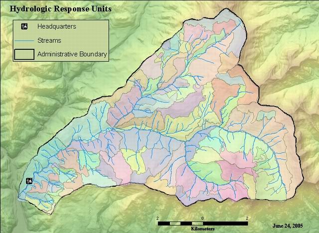
For use with the PRMS streamflow model. HRUs were created using a combination of watershed subbasins, soils, hydrography, and vegetation data layers. The combined coverage was edited to for use in the model. Soil polygons were grouped according to soil texture, other component layers were of good quality.
Hydrologic Response Units. Base units for PRMS streamflow model. Created by Alok Sikka as part of landscape runoff modeling.
There are no credits for this item.
While substantial efforts are made to ensure the accuracy of data and documentation, complete accuracy of data sets cannot be guaranteed. All data are made available "as is". The Andrews LTER shall not be liable for damages resulting from any use or misinterpretation of data sets.
Extent
West | -122.262380 | East | -122.101005 |
North | 44.281923 | South | 44.197408 |
Maximum (zoomed in) | 1:5,000 |
Minimum (zoomed out) | 1:150,000,000 |
publication date
Access constraints: Available on-line
Use constraints: See data access policy at www.fsl.orst.edu/lter/data.cfm (especialy the data use policy)
While substantial efforts are made to ensure the accuracy of data and documentation, complete accuracy of data sets cannot be guaranteed. All data are made available "as is". The Andrews LTER shall not be liable for damages resulting from any use or misinterpretation of data sets.
Obtain information off of WWW site, call contact person for special requests.
Call contact person for instructions and costs.
polygon attribute table
FSL Metadata Document
Internal feature number.
ESRI
Feature geometry.
ESRI
Area of feature in internal units squared.
ESRI
Perimeter of feature in internal units.
ESRI
Internal feature number, from coverage format.
FSL Metadata Document
user defined feature number.
FSL Metadata Document
intermediate reference number from tenthru3 layer
FSL Metadata Document
intermediate reference number from tenthru3 layer
FSL Metadata Document
intermediate reference number from tenthru layer
FSL Metadata Document
intermediate reference number from tenthru layer
FSL Metadata Document
intermediate reference number from spoilveg layer
FSL Metadata Document
ntermediate reference number from spoilveg layer
FSL Metadata Document
intermediate reference number (not part of the product)
fsl doc metadata
ntermediate reference number from hfbas_pj layer
FSL Metadata Document
ntermediate reference number from hfbas_pj layer
FSL Metadata Document
intermediate analysis code
FSL Metadata Document
intermediate reference number, for the elevation layer
FSL Metadata Document
intermediate reference number, for the elevation layer
FSL Metadata Document
area in hectares (area / 10000)
FSL Metadata Document
intermediate reference number, for the gagws layer
FSL Metadata Document
intermediate reference number, for the gagws layer
FSL Metadata Document
gaged watershed number
FSL Metadata Document
polygon perimeter (value = kilometer)
FSL Metadata Document
aspect code
FSL Metadata Document
predominant vegetation code
FSL Metadata Document
soil series
FSL Metadata Document
slope (percent)
FSL Metadata Document
slope code
FSL Metadata Document
combination of ecode, acode, vcode, dcode, scode
FSL Metadata Document
elevation code
FSL Metadata Document
hru reference number
FSL Metadata Document
dominant aspect value in hru
FSL Metadata Document
mean slope value of polygon
FSL Metadata Document
mean elevation of polygon (meters)
FSL Metadata Document
Hydrologic Response Units. Base units for PRMS streamflow model. Created by Alok Sikka as part of landscape runoff modeling.
For use with the PRMS streamflow model. HRUs were created using a combination of watershed subbasins, soils, hydrography, and vegetation data layers. The combined coverage was edited to for use in the model. Soil polygons were grouped according to soil texture, other component layers were of good quality.
publication date
Available on-line
See data access policy at www.fsl.orst.edu/lter/data.cfm (especialy the data use policy)
fair: soil ppolygons were grouped according to soil texture, other component layers were of a good quality
HRUs were created using a combination of watershed subbasins, soils, hydrograpy, and vegetation data layers. The combined coverage was edited for use in the model.
All intermediate coverages reside on optical disk as well as AMLs for determining dominant aspect, soil, and seral stage and mean slope and elevation. These programs are named: domaspect.aml, domsoil.aml, rveg.aml, elevmean.aml, and slopeavg.aml. These parameters are required by the PRMS model.
Dataset did not line up with existing UTM Zone 10, NAD27 data. An earlier shift was done. George Lienkaemper corrected by the following proceedure: Dataset moved by projecting it to NAD83 with an xshift of 84.0 and a yshift or 10.0. Projectdefine your new coverage as NAD27
Dataset copied.
Dataset copied.
While substantial efforts are made to ensure the accuracy of data and documentation, complete accuracy of data sets cannot be guaranteed. All data are made available "as is". The Andrews LTER shall not be liable for damages resulting from any use or misinterpretation of data sets.
Obtain information off of WWW site, call contact person for special requests.