Shapefile
Tags
hydrography data, HJ Andrews,
Oregon, Lookout Creek, streams, Western Cascades, streamflow, aquatic habitat, stream order,
hydrology/water, stream hydrology
Prepared as a base layer in the HJ Andrews GIS database
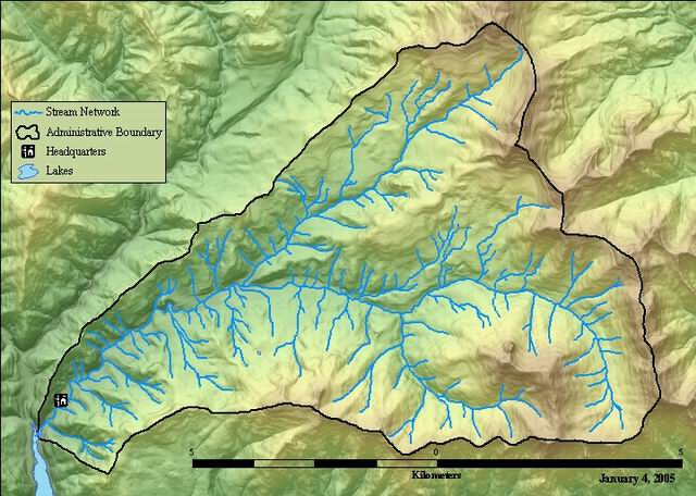
HJ Andrews Experimental Forest Stream Network. This base layer was developed from field data and edge-matched data from GSC dems (scanned contours).
George Lienkaemper
While substantial efforts are made to ensure the accuracy of data and documentation, complete accuracy of data sets cannot be guaranteed. All data are made available "as is". The Andrews LTER shall not be liable for damages resulting from any use or misinterpretation of data sets.
Extent
West | -122.262071 | East | -122.110515 |
North | 44.277582 | South | 44.200344 |
Maximum (zoomed in) | 1:5,000 |
Minimum (zoomed out) | 1:150,000,000 |
George Lienkaemper
ground condition
Access constraints: Available on line
Use constraints: See data access policy at www.fsl.orst.edu/lter/data.cfm (especially the data use policy)
While substantial efforts are made to ensure the accuracy of data and documentation, complete accuracy of data sets cannot be guaranteed. All data are made available "as is". The Andrews LTER shall not be liable for damages resulting from any use or misinterpretation of data sets.
polyline attribute table
esri
Internal feature number.
ESRI
Feature geometry.
ESRI
Internal node number for the beginning of an arc (from-node).
esri
Internal node number for the end of an arc (to-node).
esri
Length of feature in internal units.
ESRI
unique whole number, identifier in Arc/Info coverage format
esri
user defined unique number
Internal documentation
Watershed basin stream is located in
FSDB metadata documentation
unknown
none
stream order: In the Strahler method, all links without any tributaries are assigned an order of 1 and are referred to as first order. The stream order increases when streams of the same order intersect. Therefore, the intersection of two first-order links will create a second-order link, the intersection of two second-order links will create a third-order link, and so on. The intersection of two links of different orders, however, will not result in an increase in order. For example, the intersection of a first-order and second-order link will not create a third-order link but will retain the order of the highest ordered link. The Strahler method is the most common stream ordering method. However, because this method only increases in order at intersections of the same order, it does not account for all links and can be sensitive to the addition or removal of links.
esri
HJ Andrews Experimental Forest Stream Network. This base layer was developed from field data and edge-matched data from GSC dems (scanned contours).
Prepared as a base layer in the HJ Andrews GIS database
ground condition
Available on line
See data access policy at www.fsl.orst.edu/lter/data.cfm (especially the data use policy)
George Lienkaemper
Comment: Very Good
Data complete for the entire basin
Prepared from Lienkaemper's 1976 stream survey field data and contours generated from GSC DEMs
This layer was developed through in 1976 by George Lienkaemper. The first surveys was in April when the stream system was very extended (and included many intermittent streams) and another in August and September (when the network was quite contracted). The "survey"was done using the road network and the old 4"/mile Forest Service maps. If a stream crossed a road, it was extended that far on the map. If it didn't cross the next road up, he tried to track it down to where surface water first appeared and then estimate the location on the maps. The survey consisted of 8.5 x 11 photocopies pieces of the larger map taped together.
Added stream order through David Hatfields program called "order" and reviewed results with Sherri Johnson and made hand changes to order 5. (1/27/05) Theresa Valentine
Dataset copied.
Dataset copied.
Unknown
call/email or access the data a web site http://www.fsl.orst.edu/lter/datafr.htm
While substantial efforts are made to ensure the accuracy of data and documentation, complete accuracy of data sets cannot be guaranteed. All data are made available "as is". The Andrews LTER shall not be liable for damages resulting from any use or misinterpretation of data sets.
Local area network