Shapefile
Tags
forest land management practices,
Blue River Watershed, Oregon, HJ Andrews Experimental Forest, geology/geomorphology,
administration, Willamette Basin, experimental forest management
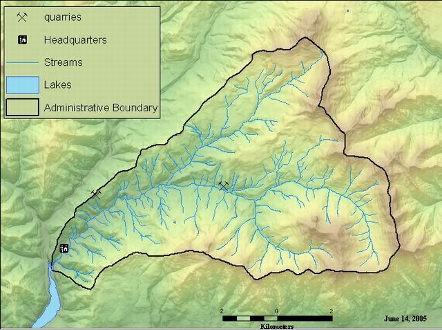
To document the quarry locations and to assist in preperation of the Andrews base map.
Geographic Location of quarries in the Andrews Experimental Forest.
There are no credits for this item.
While substantial efforts are made to ensure the accuracy of data and documentation, complete accuracy of data sets cannot be guaranteed. All data are made available "as is". The Andrews LTER shall not be liable for damages resulting from any use or misinterpretation of data sets.
Extent
West | -122.239806 | East | -122.182349 |
North | 44.232737 | South | 44.229204 |
Maximum (zoomed in) | 1:5,000 |
Minimum (zoomed out) | 1:150,000,000 |
publication date
Access constraints: Available on-line
Use constraints: See data access policy at www.fsl.orst.edu/lter (especially the data use policy)
While substantial efforts are made to ensure the accuracy of data and documentation, complete accuracy of data sets cannot be guaranteed. All data are made available "as is". The Andrews LTER shall not be liable for damages resulting from any use or misinterpretation of data sets.
Obtain information off of WWW site, call contact person for special requests.
Call contact person for instructions and costs.
point layer
esri
Internal feature number.
ESRI
Feature geometry.
ESRI
unique identifier for the quarry
source
Locations of quarries in the Andrews Experimental Forest.
To document the quarry locations and to assist in preperation of the Andrews base map.
publication date
Available on-line
See data access policy at www.fsl.orst.edu/lter (especially the data use policy)
fair, (see process step)
Quarry locations were drawn on Andrews Experimental Forest base map. The locations were then on-screen digitized into an Arc/Info coverage.
Dataset moved.
Dataset copied.
Dataset copied.
While substantial efforts are made to ensure the accuracy of data and documentation, complete accuracy of data sets cannot be guaranteed. All data are made available "as is". The Andrews LTER shall not be liable for damages resulting from any use or misinterpretation of data sets.
Obtain information off of WWW site, call contact person for special requests.