Shapefile
Tags
boundary, watershed,
Willamette Basin, basin, Oregon, Blue River Watershed, HJ Andrews Experimental
Forest
All research conducted at the HJA is subject to general standards and policies of scientific conduct. To initiate a new research project, submit a research proposal to the Andrews Forest Director. Research proposals determined to have a potentially significant impact on the forest or other ongoing research projects must be presented to the site committee, which meets the first Friday of every month from September-June, for approval. All major manipulative experiments will be advertised to the scientific community with the intent of increasing collaboration and maximizing field site utilization.
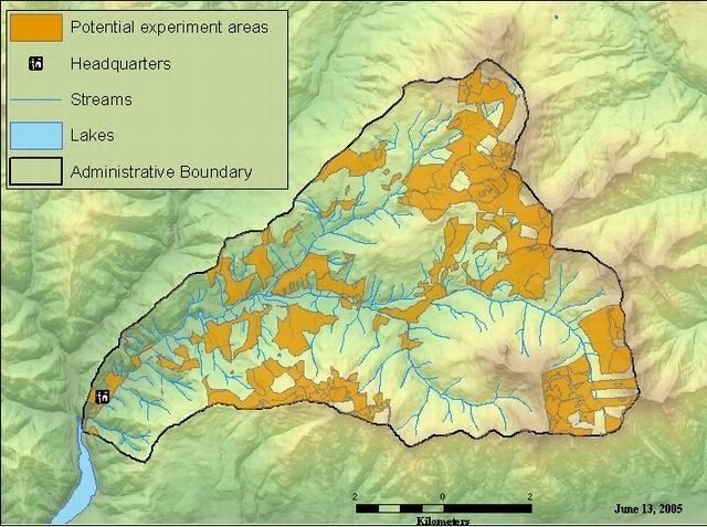
This layer contains areas available for consideration for potential experiments on the Andrews Experimental Forest. All reserved, controlled, and harvested areas have been removed.
There are no credits for this item.
While substantial efforts are made to ensure the accuracy of data and documentation, complete accuracy of data sets cannot be guaranteed. All data are made available "as is". The Andrews LTER shall not be liable for damages resulting from any use or misinterpretation of data sets.
Extent
West | -122.261694 | East | -122.100951 |
North | 44.281964 | South | 44.199874 |
Maximum (zoomed in) | 1:5,000 |
Minimum (zoomed out) | 1:500,000 |
visit the website @ http://andrewsforest.oregonstate.edu/lter/data/metadata.cfm?topnav=115
publication date
This data is a representation of the legal boundary of the HJ Andrews Experimental Forest. The Willamette National Forest should be contacted for the legal, surveyed boundary of the forest, according to the establishment records.
no legal constraints on use of this data. We ask that the following Acknowledgements be made: http://andrewsforest.oregonstate.edu/lter/acknowledgements.cfm
While substantial efforts are made to ensure the accuracy of data and documentation, complete accuracy of data sets cannot be guaranteed. All data are made available "as is". The Andrews LTER shall not be liable for damages resulting from any use or misinterpretation of data sets.
This dataset was generated by taking the watershed boundary of the Andrews, subtracting the control areas, LSR's, and the harvest units. The remaining area are areas that have potential for experiments, where the area may be relatively undisturbed.
Obtain information off of WWW site, call contact person for special requests.
Call contact person for instructions and costs.
polygon layer
processor
internal field
ESRI
internal field
ESRI
polgyon area in square meters as calculated using calculate areas command
esri
The Administrative Boundary of the HJ Andrews Experimental Forest
The boundary was developed to show the administrative and watershed boundary of the HJ Andrews Experimental Forest.
158_01
publication date
Available on-line
See data access policy at www.fsl.orst.edu/lter/data (especialy the data use policy)
Data Set created by Tere Turner, Blue River Ranger District, WIllamette National Forest
Fair (more accurate then bound_old as determined by PI's for the HJ Andrews LTER site)
Complete boundary for the HJ Andrews Experimental Forest
The coverage was digitized from USFS Primary Base Series topographic maps and edited in ArcEdit. The dataset was built (completed topology).
Dataset copied.
Dataset copied.
While substantial efforts are made to ensure the accuracy of data and documentation, complete accuracy of data sets cannot be guaranteed. All data are made available "as is". The Andrews LTER shall not be liable for damages resulting from any use or misinterpretation of data sets.
Local area network
Obtain information off of WWW site, call contact person for special requests.