Shapefile
Tags
Willamette Basin, Blue
River Watershed, road networks, administration, road management, Oregon, gates, program
administration, HJ Andrews Experimental Forest, roads
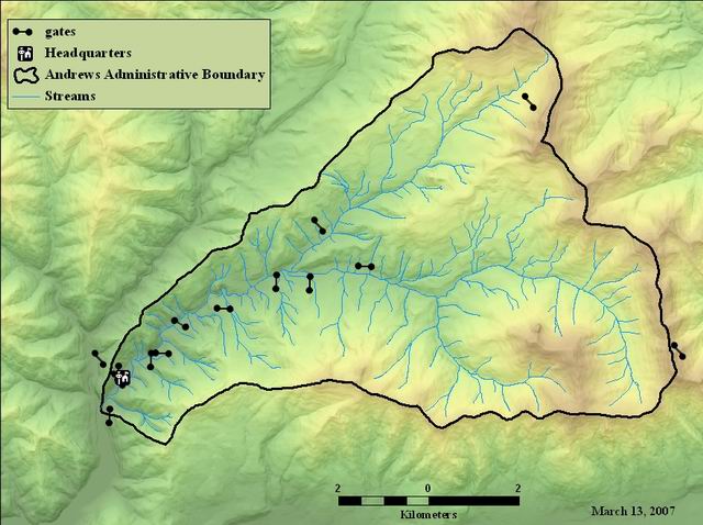
The gates were located to update the Andrews Experimental Forest Map and to help manage the facility.
Road gate locations for the Andrews Experimental Forest.
There are no credits for this item.
While substantial efforts are made to ensure the accuracy of data and documentation, complete accuracy of data sets cannot be guaranteed. All data are made available "as is". The Andrews LTER shall not be liable for damages resulting from any use or misinterpretation of data sets.
Extent
West | -122.262164 | East | -122.100280 |
North | 44.267335 | South | 44.203507 |
Maximum (zoomed in) | 1:5,000 |
Minimum (zoomed out) | 1:150,000,000 |
publication date
Access constraints: Available on-line
Use constraints: See data access policy at www.fsl.orst.edu/lter/data (especialy the data use policy)
While substantial efforts are made to ensure the accuracy of data and documentation, complete accuracy of data sets cannot be guaranteed. All data are made available "as is". The Andrews LTER shall not be liable for damages resulting from any use or misinterpretation of data sets.
Obtain information off of WWW site, call contact person for special requests.
Call contact person for instructions and costs.
point data
source
internal field
ESRI
internal field
ESRI
identification number (blank) from previous version of software.
FSL metadata documentation
degree symbols are to be rotated to plot on maps
source
Road gate locations for the Andrews Experimental Forest.
The gates were located to update the Andrews Experimental Forest Map and to help manage the facility.
publication date
Available on-line
See data access policy at www.fsl.orst.edu/lter/data (especialy the data use policy)
Fair, on-screen digitized from locations placed on hard copy map. Results were verified by Andrews staff.
Gate locations as of summer 2004
The shapefile was digitized on-screen from map locations that were placed on hard copy of Andrews Base Map. The results were verified by Andrews field staff, and the resulting points were converted to a shapefile. An attribute was added to insure the proper orientation of gate symbols for the map.
Dataset copied.
Metadata imported.
Dataset copied.
While substantial efforts are made to ensure the accuracy of data and documentation, complete accuracy of data sets cannot be guaranteed. All data are made available "as is". The Andrews LTER shall not be liable for damages resulting from any use or misinterpretation of data sets.
Local area network
Obtain information off of WWW site, call contact person for special requests.