Shapefile
Tags
Willamette National
Forest, geomorphology, Oregon, movement monitoring, debris slides, Cascade Range,
Landslides, H J Andrews Experimental Forest, slope stability
These data collection efforts represent a variety of research objectives. Primarily data were collected to document landslide occurence in managed forest lands of the western Cascade Range and to assess the impact of road-building and timber harvest on landslide magnitude and frequency.
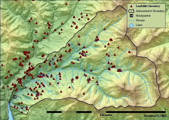
Shape file of landslide occurrences in the vicinity of the H. J. Andrews Experimental Forest. This layer is a combination of data from four landslide inventory efforts that have been conducted in the area beginning in the late 1960's. Data represent landslide occurrences between 1953 and 1996. Data are in the UTM coordinate system; zone 10, NAD27.
The data table that describes the characteristics of the landslides inventoried in the following: Individual layers tied to inventories by Ted Dyrness, Fred Swanson, Dan Marion, and Matt Wallenstein were appended and linked to the shape file. This file is associated with the slideinv layer, which is a combination of data from four landslide inventory efforts that have been conducted in the area beginning in the late 1960's. Points have been screen digitized from field maps using streams, roads, contour lines, and harvest units as reference layers.
Landslide inventory field collections were conducted by Ted Dyrness, Fred Swanson, Dan Marion, and Matt Wallenstein. Data sets were provided by the Forest Science Data Bank, a partnership between the Department of Forest Science, Oregon State University, and the U.S. Forest Service Pacific Northwest Research Station, Corvallis, Oregon. Significant funding for these data was provided by the National Science Foundation Long-Term Ecological Research program (NSF Grant numbers BSR-90-11663 and DEB-96-32921).
There are no access and use limitations for this item.
Extent
West | -122.311695 | East | -122.132412 |
North | 44.322416 | South | 44.188585 |
Maximum (zoomed in) | 1:5,000 |
Minimum (zoomed out) | 1:150,000,000 |
Landslide inventory field collections were conducted by Ted Dyrness, Fred Swanson, Dan Marion, and Matt Wallenstein. Data sets were provided by the Forest Science Data Bank, a partnership between the Department of Forest Science, Oregon State University, and the U.S. Forest Service Pacific Northwest Research Station, Corvallis, Oregon. Significant funding for these data was provided by the National Science Foundation Long-Term Ecological Research program (NSF Grant numbers BSR-90-11663 and DEB-96-32921).
ground condition
Access constraints: None
Use constraints: Please refer to H J Andrews/LTER data use agreement - http://www.fsl.orst.edu/lter/data.cfm
point feature class with attributes
esri
Internal feature number.
Esri
Feature geometry.
Esri
internally generated unique whole number
esri
user defined unique number. not sure if any significance.
fsl metadata documents
investigator
fsl metadata documents
unique number for each slide (see link for range identifier)
fsl metadata document
numeric link to attributes (slide reference number) 000 - Dynress 2000 - Swanson 3000 - Marion 4000 - Wallenstein
fsl metadata documents
unknown value. all values are 1
not documented
unknown
unknown
values unknown
not documented
study code from Forest Science Data Bank.
fsl metadata docs
format
fsl metadata documents
unique slide identification number
fsl doc metadata
year of occurence
fsl metadata document
location of slide
fsl metadata document
primary land use at origin of landslide.
fsl metadata document
secondary land use at origin of landslide.
fsl metadata documents
slope steepness at landslide occurence (in degrees)
fsl metadata document
aspect of slope at landslide occurence (in degrees)
fsl metadata document
aspect of slope at landslide occurence
fsl metadata document
elevation at initiation site (feet)
fsl metadata document
average width of debris slide scar
fsl metadata document
average length of debris slide scar
fsl metadata document
average depth of debris slide scar (value in meters)
fsl metadata document
average area of debrtis slide scar
fsl metadata document
estimate volume of debris slide inorganic component (in cubic meters)
fsl metadata document
estimated percent of material delivered to stream
fsl metadata document
land use interpreted as probable cause of slide
fsl metadata document
is there a road nearby?
fsl metadata document
how confident are you that 'origin' is the cause of the slide? unit is percent
fsl metadata document
geomorphic setting at initation site
fsl metadata document
secondary geomorphic setting at initation site
fsl metadata document
date of road construction associated with slide
fsl metadata document
date of cutting associates with slide
fsl metadata document
did a debris flow result from slide?
fsl metadata document
was slide visible on 1:12000 aerial photos
fsl metadata document
is slide visible on 1:64000 aerial photos?
fsl metadata document
site type at termination of slide
fsl metadata doc
angle at which slide entered channel
fsl metadata doc
volume of slide inorganic component
fsl metadata doc
average slope of landslide in percent
fsl metadata document
year of most recent disturbance
fsl metadata doc
what did slide transform into before stopping?
fsl metadata doc