Shapefile
Tags
riparian, hydrology,
Blue River Watershed, HJ Andrews Experimental Forest, Oregon, coarse woody debris,
Willamette Basin
For analysis of flood hazard
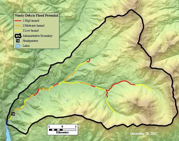
Coarse Woody Debris Flood Potential. This data layer identifies the susceptibility to floods with coarse woody debris of 3rd order or higher streams (Lookout, McCrae, and part of Mack creeks).
There are no credits for this item.
While substantial efforts are made to ensure the accuracy of data and documentation, complete accuracy of data sets cannot be guaranteed. All data are made available "as is". The Andrews LTER shall not be liable for damages resulting from any use or misinterpretation of data sets.
Extent
West | -122.261908 | East | -122.110166 |
North | 44.275650 | South | 44.200175 |
Maximum (zoomed in) | 1:5,000 |
Minimum (zoomed out) | 1:150,000,000 |
ground condition
Access constraints: Available on-line
Use constraints: See data access policy at www.fsl.orst.edu/lter/data.cfm (especially the data use policy)
While substantial efforts are made to ensure the accuracy of data and documentation, complete accuracy of data sets cannot be guaranteed. All data are made available "as is". The Andrews LTER shall not be liable for damages resulting from any use or misinterpretation of data sets.
Obtain information off of WWW site, call contact person for special requests.
Call contact person for instructions and costs.
Coarse woody debris arc attribute table
fsldoc
Internal feature number.
ESRI
Feature geometry.
ESRI
from node (indicates direction of the arcs)
esri
to node: direction of the flow of the stream network
esri
Length of feature in internal units. (meters)
ESRI
unique whole number
esri
unique whole number, user defined
esri
coarse woody debris flood hazard
fsldoc metadata
Coarse Woody Debris Flood Potential. This data layer identifies the susceptibility to floods with coarse woody debris of 3rd order or higher streams (Lookout, McCrae, and part of Mack creeks).
For analysis of flood hazard
ground condition
Available on-line
See data access policy at www.fsl.orst.edu/lter/data.cfm (especially the data use policy)
First estimation including unkown things such as initiation and stopping conditions of coarse woody debris flood.
Data was derived from hydrography layer and digitized in-house.
Dataset copied.
Dataset copied.
While substantial efforts are made to ensure the accuracy of data and documentation, complete accuracy of data sets cannot be guaranteed. All data are made available "as is". The Andrews LTER shall not be liable for damages resulting from any use or misinterpretation of data sets.
Obtain information off of WWW site, call contact person for special requests.