Shapefile
Tags
HJ Andrews, geology,
Oregon, WIllamette Basin, minerology, Blue River Watershed
To support research management i.e. study site selection, infrastructure improvement, and climate summaries within the HJ Andrews Experimental Forest
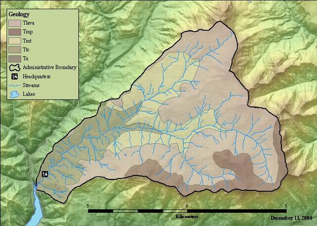
Rock units of parts of the Blue River basin (including the Lookout Creek watershed and upper Blue River above the junction with Lookout Creek), were described by several investigators who covered different portions of the basin at different scales. A unit correlation table was developed (see below) and units were manuscripted using Priest .et .al (1988) for Lookout Creek and Walker and Duncan (1989) for upper Blue River. Units were digitized and attributed using the investigators' descriptions. The upper Blue River geology layer was clipped by the H.J. Andrews boundary to create this layer. Rock unit strength was added as an attribute when the geology layer was used in a landslide hazard analysis. Rock strength was determined by Swanson based on rock type and age.
Walker, Duncan, Priest, Swanson, and James
While substantial efforts are made to ensure the accuracy of data and documentation, complete accuracy of data sets cannot be guaranteed. All data are made available "as is". The Andrews LTER shall not be liable for damages resulting from any use or misinterpretation of data sets.
Extent
West | -122.262494 | East | -122.100927 |
North | 44.281987 | South | 44.197475 |
Maximum (zoomed in) | 1:5,000 |
Minimum (zoomed out) | 1:150,000,000 |
Walker, Duncan, Priest, Swanson, and James
publication date
Access constraints: Available on Line
Use constraints: See data access policy at www.fsl.orst.edu/lter/data.cfm (especially the data use policy)
While substantial efforts are made to ensure the accuracy of data and documentation, complete accuracy of data sets cannot be guaranteed. All data are made available "as is". The Andrews LTER shall not be liable for damages resulting from any use or misinterpretation of data sets.
Obtain the data from the website: http://www.fsl.orst.edu/lter/datafr.htm Call the distribution number if you can not access the website.
Geology for Blue River Watershed Polygon Attribute Table
FSLDOC metadata
Internal feature number.
ESRI
Feature geometry.
ESRI
area in square meters
ESRI
perimeter in meters
ESRI
unique number for polygon
FSLDOC metadata
unknown, legacy from coverage format
FSLDOC metadata
Geologic rock unit
FSLDOC metadata
rock unit strength
FSLDOC metatdata
rock strength for use in Nakamura's variable program
FSLDOC metadata
Rock units of parts of the Blue River basin (including the Lookout Creek watershed and upper Blue River above the junction with Lookout Creek), were described by several investigators who covered different portions of the basin at different scales. A unit correlation table was developed (see below) and units were manuscripted using Priest .et .al (1988) for Lookout Creek and Walker and Duncan (1989) for upper Blue River. Units were digitized and attributed using the investigators' descriptions. The upper Blue River geology layer was clipped by the H.J. Andrews boundary to create this layer. Rock unit strength was added as an attribute when the geology layer was used in a landslide hazard analysis. Rock strength was determined by Swanson based on rock type and age.
To support research management i.e. study site selection, infrastructure improvement, and climate summaries within the HJ Andrews Experimental Forest
publication date
Available on Line
See data access policy at www.fsl.orst.edu/lter/data.cfm (especially the data use policy)
Walker, Duncan, Priest, Swanson, and James
Fair, detail is limited by the coarsest resolution source (1:250,000)
Geologic maps
Rock units of parts of the Blue River basin (including the Lookout Creek watershed and upper Blue River above the junction with Lookout Creek), were described by several investigators who covered different portions of the basin at different scales. A unit correlation table was developed (see below) and units were manuscripted using Priest .et .al (1988) for Lookout Creek and Walker and Duncan (1989) for upper Blue River. Units were digitized and attributed using the investigators' descriptions. The upper Blue River geology layer was clipped by the H.J. Andrews boundary to create this layer. Rock unit strength was added as an attribute when the geology layer was used in a landslide hazard analysis. Rock strength was determined by Swanson based on rock type and age.
Rock Unit Correlation Table
Walker& Priest* Description Age
Duncan et al (mybp)
----------------------------------------------------------------------
Tb Tlava [Tmp, ridge capping lava flows 4-8
Tmf not shown]
Tba Tma, Tmb, Tml some Tb lava flows, minor clastics 8-13
Tu Tmt clastics, especially ashflows ~14
Ttc clastics 18-25
[Ta not shown] as minor inclusions
Tmv Wolf Rock and other minor intrusive Mio -
bodies Olig
-----------------------------------------------------------------------
* map unit boundaries are a mixture of Priest etal and Swanson and
James (1975) for their mapped areas
Dataset copied.
Dataset copied.
While substantial efforts are made to ensure the accuracy of data and documentation, complete accuracy of data sets cannot be guaranteed. All data are made available "as is". The Andrews LTER shall not be liable for damages resulting from any use or misinterpretation of data sets.
Local area network
Obtain the data from the website: http://www.fsl.orst.edu/lter/datafr.htm
Call the distribution number if you can not access the website.