Shapefile
Tags
mapping, HJA, Western
Cascades, Oregon, road management, Blue River, HJ Andrews Experimental Forest,
roads
To support research management within the HJ Andrews Experimental Forest and to document the development of the transportation network over time.
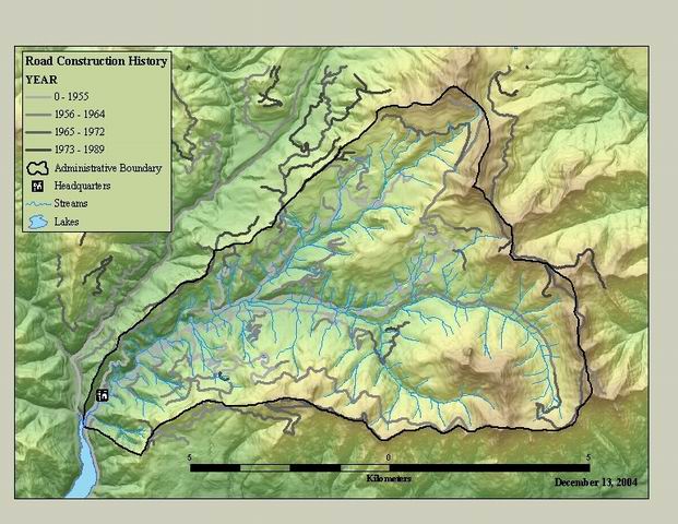
Andrews Road Construction History. This data includes the year and 1/2 decade of construction for the road network around the HJ Andrews Experimental Forest.
There are no credits for this item.
While substantial efforts are made to ensure the accuracy of data and documentation, complete accuracy of data sets cannot be guaranteed. All data are made available "as is". The Andrews LTER shall not be liable for damages resulting from any use or misinterpretation of data sets.
Extent
West | -122.269620 | East | -122.096561 |
North | 44.286545 | South | 44.192577 |
Maximum (zoomed in) | 1:5,000 |
Minimum (zoomed out) | 1:150,000,000 |
publication date
Access constraints: Available on-line
Use constraints: See data access policy at www.fsl.orst.edu/lter/data.fr.htm (especially the data use policy)
While substantial efforts are made to ensure the accuracy of data and documentation, complete accuracy of data sets cannot be guaranteed. All data are made available "as is". The Andrews LTER shall not be liable for damages resulting from any use or misinterpretation of data sets.
Obtain information off of WWW site, call contact person for special requests.
Call contact person for instructions and costs.
roads arc attribute table
esri
Internal feature number.
ESRI
Feature geometry.
ESRI
Internal node number for the beginning of an arc (from-node).
esri
Internal node number for the end of an arc (to-node).
esri
Internal node number for the left polygon.
esri
Internal node number for the right polygon
esri
Length of feature in internal units.
ESRI
unique number from coverage format
esri
Unique numbers that are either computer or user defined. No documentation as this is a carry over from the esri coverage format.
FSDB documentation
year of road construction
FSDB documentation
half-decade of construction
author
This code appears to be the status of the road at some point. This is a best guess after talking to staff. Note that this information has not been maintained and is very sketchy.
conversations with staff
Andrews Road Construction History. This data includes the year and 1/2 decade
of construction for the road network around the HJ Andrews Experimental
Forest.
To support research management within the HJ Andrews Experimental Forest and to
document the development of the transportation network over time.
publication date
Available on-line
See data access policy at www.fsl.orst.edu/lter/data.fr.htm (especially the data
use policy)
digitized from 1:60000 air photos, using AP190 analytical stereo
plotter
Dataset copied.
Metadata imported.
Dataset copied.
While substantial efforts are made to ensure the accuracy of data and
documentation, complete accuracy of data sets cannot be guaranteed. All data are made
available "as is". The Andrews LTER shall not be liable for damages resulting from any
use or misinterpretation of data sets.
Obtain information off of WWW site, call contact person for special
requests.