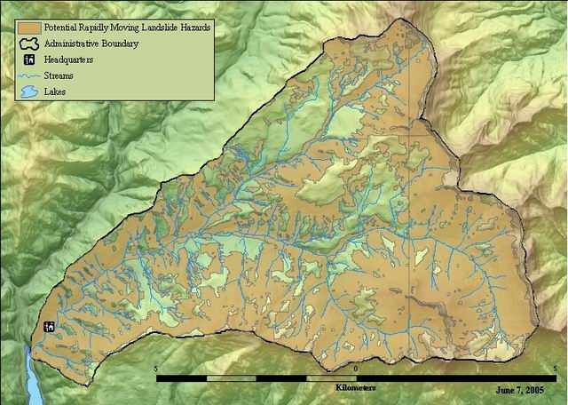
Potential rapidly moving landslide hazards in Western Oregon, clipped to Andrews Experimental Forest.

Shapefile
Thumbnail

Tags
Oregon, Linn County, Andrews Experimental Forest, Tillamook County, Yamhill County, Jackson County, Curry County, Washington County, Douglas County, Lincoln County, Hood River County, Benton County, Lane County, Clackamas County, Columbia County, Marion County, Clatsop County, Josephine County, Coos County, Geologic hazard, Multnomah County, Polk County, Potential Rapidly Moving Landslide hazard


Summary

To address the most dangerous landslide hazards in Oregon systematically.

Description

Landslides are a serious geologic hazard, threatening public safety, natural resources, and infrastructure, and costing millions of dollars for repairs each year in Oregon. This map of areas where rapidly moving landslides pose hazards in western Oregon is part of the State's attempt to protect lives and property. The overview map delineates zones that are prone to landslide hazards, especially rapidly moving landslides. These zones provide information to local governments about property that might require more site-specific evaluation. The map is in digital format and was produced with data at a scale of 1:24,000 (1 in. = 2,000 ft). Creation of the map involved the use of Geographic Information System (GIS) modeling, checking and calibrating with limited field evaluations, and comparing with historic landslide inventories. The extent and severity of the hazard posed by rapidly moving landslides varies considerably across western Oregon. In general, the most hazardous areas are mountainous terrains, which are usually sparsely populated, especially drainage channels and depositional fans associated with debris flows. Where hazard areas intersect with human development, use of the map can help to assess the risk and prioritize risk-reduction activities. Various options are available to reduce the risk of landslide losses. Risk-reduction activities can include engineering solutions, public education, warning systems, temporary road closures and evacuation, land use regulation, and many other options. Although this project addresses a range of rapidly moving landslides, this map is not a compilation of all possible landslide hazards.

Credits

R. Jon Hofmeister, Oregon Department of Geology and Mineral Industries

Use limitations

Although these data have been processed successfully on a computer system at the Oregon Department of Geology and Mineral Industries (DOGAMI), no warranty expressed or implied is made regarding the accuracy or utility of the data on any other system or for general or scientific purposes, nor shall the act of distribution constitute any such warranty. This disclaimer applies both to individual use of the data and aggregate use with other data. It is strongly recommended that these data are directly acquired from DOGAMI, and not indirectly through other sources which may have changed the data in some way. It is also strongly recommended that careful attention be paid to the contents of the metadata file associated with these data. The Oregon Department of Geology and Mineral Industries shall not be held liable for improper or incorrect use of the data described and/or contained herein.

Extent

West  -122.261722    East  -122.100847
North  44.281956    South  44.197704

Scale Range
Maximum (zoomed in)  1:5,000
Minimum (zoomed out)  1:150,000,000

ArcGIS Metadata 

Topics and Keywords 

*Content type  Downloadable Data
Export to FGDC CSDGM XML format as Resource Description No

Place keywords  Oregon, Linn County, Andrews Experimental Forest, Lane County

Theme keywords  Geologic hazard, Potential Rapidly Moving Landslide hazard

Citation 

Title Potential rapidly moving landslide hazards in Western Oregon, clipped to Andrews Experimental Forest.
Publication date 2003-02-28 00:00:00


Edition 1


Presentation formats  digital map


Series
Name Interpretive Map Series
Issue 22

Other citation details df02601


Citation Contacts 

Responsible party
Organization's name Oregon Department of Geology and Mineral Industries
Individual's name R. Jon Hofmeister
Contact's role  publisher


Contact information
Address
Type
Delivery point Portland, OR


Responsible party
Organization's name Earth Systems Institute
Individual's name  Daniel J. Miller
Contact's role  originator


Responsible party
Individual's name Keith A. Mills
Organization's name Oregon Department of Forestry
Contact's role  originator


Responsible party
Individual's name Jason C. Hinkle
Organization's name Oregon Department of Forestry
Contact's role  originator


Responsible party
Individual's name Ann E. Beier
Organization's name Oregon Department of Land Conservation and Development
Contact's role  resource provider


Resource Details 

Dataset languages  English (UNITED STATES)
Dataset character set  utf8 - 8 bit UCS Transfer Format


Status  completed
Spatial representation type  vector


Graphic overview
File name Indexmap.pdf
File description Map showing extent and file names of map data
File type PDF

Supplemental information
Digital map information in vector format is provided for each of 19 western Oregon counties. GIS file formats provided include MapInfo .tab and ArcView .shp. This data was clipped to the boundary of the Andrews Experimental Forest. Data for the 19 western Oregon counties are available on request
*Processing environment Microsoft Windows 7 Version 6.1 (Build 7601) Service Pack 1; Esri ArcGIS 10.1.1.3143


Credits
R. Jon Hofmeister, Oregon Department of Geology and Mineral Industries
ArcGIS item properties
*Name potlandslides
*Size 0.429
*Location file://\\quercus\fordata\oregon\willamette\hja83\potlandslides.shp
*Access protocol Local Area Network

Extents 

Extent
Description
publication date
Geographic extent
Bounding rectangle
Extent type  Extent used for searching
*West longitude -122.261722
*East longitude -122.100847
*North latitude 44.281956
*South latitude 44.197704
*Extent contains the resource Yes

Temporal extent
Date and time 2003-02-28 00:00:00

Extent in the item's coordinate system
*West longitude 558992.819686
*East longitude 571747.998403
*South latitude 4894223.672681
*North latitude 4903455.629562
*Extent contains the resource Yes

Resource Points of Contact 

Point of contact
Individual's name R. Jon Hofmeister
Organization's name Oregon Department of Geology and Mineral Industries
Contact's position Geotechnical Engineer
Contact's role  point of contact


Contact information
Phone
Voice 503 731-4100 x243
Fax 503 731-4066

Address
Type both
Delivery point 800 NE Oregon Street #28 Suite 965
City Portland
Administrative area OR
Postal code 97232
Country US


Resource Maintenance 

Resource maintenance
Update frequency  unknown


Resource Constraints 

Legal constraints
Access constraints  other restrictions


Other constraints
Access constraints: None
Legal constraints
Use constraints  other restrictions


Other constraints
Use constraints: This map is in digital format and was produced with data at a scale of 1:24,000 (1 in. = 2,000 ft). Therefore, the information it provides is appropriate only at that scale or a smaller scale (e.g., 1:48,000) and cannot show greater detail if viewed at any larger scale.
Security constraints
Classification  unclassified
Classification system None


Additional restrictions None


Constraints
Limitations of use
Although these data have been processed successfully on a computer system at the Oregon Department of Geology and Mineral Industries (DOGAMI), no warranty expressed or implied is made regarding the accuracy or utility of the data on any other system or for general or scientific purposes, nor shall the act of distribution constitute any such warranty. This disclaimer applies both to individual use of the data and aggregate use with other data. It is strongly recommended that these data are directly acquired from DOGAMI, and not indirectly through other sources which may have changed the data in some way. It is also strongly recommended that careful attention be paid to the contents of the metadata file associated with these data. The Oregon Department of Geology and Mineral Industries shall not be held liable for improper or incorrect use of the data described and/or contained herein.

Spatial Reference 

ArcGIS coordinate system
*Type Projected
*Geographic coordinate reference GCS_North_American_1983
*Projection NAD_1983_UTM_Zone_10N
*Coordinate reference details
Projected coordinate system
Well-known identifier 26910
X origin -5120900
Y origin -9998100
XY scale 450445547.3910538
Z origin -100000
Z scale 10000
M origin -100000
M scale 10000
XY tolerance 0.001
Z tolerance 0.001
M tolerance 0.001
High precision true
Latest well-known identifier 26910
Well-known text PROJCS["NAD_1983_UTM_Zone_10N",GEOGCS["GCS_North_American_1983",DATUM["D_North_American_1983",SPHEROID["GRS_1980",6378137.0,298.257222101]],PRIMEM["Greenwich",0.0],UNIT["Degree",0.0174532925199433]],PROJECTION["Transverse_Mercator"],PARAMETER["False_Easting",500000.0],PARAMETER["False_Northing",0.0],PARAMETER["Central_Meridian",-123.0],PARAMETER["Scale_Factor",0.9996],PARAMETER["Latitude_Of_Origin",0.0],UNIT["Meter",1.0],AUTHORITY["EPSG",26910]]

Reference system identifier
Value 26910
*Codespace EPSG
*Version 7.11.2


Spatial Data Properties 

Vector
*Level of topology for this dataset  geometry only


Geometric objects
Feature class name potlandslides
*Object type  composite
*Object count 52


ArcGIS Feature Class Properties
Feature class name potlandslides
*Feature type Simple
*Geometry type Polygon
*Has topology FALSE
*Feature count 52
*Spatial index TRUE
*Linear referencing FALSE


Data Quality 

Scope of quality information
Resource level  dataset


Data quality report - Topological consistency
Evaluation method Spatial data is presented in the form of polygons delineating potential rapidly moving landslide hazard zones, areas not in hazard zones are not accounted for spatially. This dataset does not have topology.


Data quality report - Conceptual consistency
Measure description Spatial data is presented in the form of polygons delineating potential rapidly moving landslide hazard zones, areas not in hazard zones are not accounted for spatially. This dataset does not have topology.


Data quality report - Completeness omission
Measure description The text and accompanying map data are designed to identify areas subject to rapidly moving landslide hazards for 19 western Oregon counties.


Data quality report - Quantitative attribute accuracy
Measure description Very good. The landslide model data output, while gradational, was queried to develop only the high-hazard zone. This output is subject to little or no attribute accuracy errors.


Data quality report - Absolute external positional accuracy
Measure description The map data are intended to be used at a scale of 1:24,000, and the hazard information is stored at the original 10-meter DEM (digital elevation model) spacing.


Quantitative test results
Value 10


Evaluation method U.S. Geological Survey National Map Accuracy Standard for 1:24,000 scale topographic quadrangle maps.


Lineage 

Process step
When the process occurred 2003-01-15 00:00:00
Description This landslide data was developed through an iterative process that included multiple phases of GIS screening, field data collection, inventory comparisons, and peer reviews. For this final release of the data, further processing by GIS software was done to improve data quality. The following tasks were completed: -the county boundary file was corrected to remove small 'no data' areas , and checked for topology. -the Oregon coast shoreline was improved using a NOAA-developed shoreline file obtained from the Oregon Department of Land Conservation and Development. -a 100-meter westward buffer was applied to the new shoreline along the entire Oregon coast. -a 100-meter buffer was applied beyond the perimeter of each county data file (and subsections) to ensure data continuity. -very small polygons (<450 square meters) were removed.


Process contact
Individual's name R. Jon Hofmeister
Organization's name Oregon Department of Geology and Mineral Industries
Contact's position Geotechnical Engineer
Contact's role  processor


Contact information
Phone
Voice 503 731-4100 x243
Fax 503 731-4066


Process step
When the process occurred 2011-06-15 00:00:00
Description Data was clipped to the boundary of the Andrews Experimental Forest


Process contact
Individual's name Theresa Valentine
Organization's name Corvallis Forest Science Laboratory
Contact's position Spatial Information Manager
Contact's role  processor


Contact information
Phone
Voice 541-750-7333
Fax 541-758-7760

Address
Type both
Delivery point 3200 SW Jefferson Way
City Corvallis
Administrative area Oregon
Postal code 97332
Country US
e-mail addresstvalentine@fs.fed.us or theresa.valentine@orst.edu

Hours of service m-f 8:00am-4:00pm


Process step
When the process occurred 2011-06-15 00:00:00
Description projected from NAD27 to NAD83
Rationale to meet requirements of US Forest Service


Process contact
Individual's name Theresa Valentine
Organization's name Corvallis Forest Science Laboratory
Contact's position Spatial Information Manager
Contact's role  processor


Contact information
Phone
Voice 541-750-7333
Fax 541-758-7760

Address
Type both
Delivery point 3200 SW Jefferson Way
City Corvallis
Administrative area Oregon
Postal code 97332
Country US
e-mail addresstvalentine@fs.fed.us or theresa.valentine@orst.edu

Hours of service m-f 8:00am-4:00pm


Source data
Description The text accompanying IMS-22 describes the GIS model, calibrations, and limited field evaluations used to derive the polygons, and contains a complete listing of references cited.


Resolution of the source data

Source citation
Title IMS-22 GIS Overview Map of Potential Rapidly Moving Landslide Hazards in Western Oregon
Publication date 2003-02-28 00:00:00


Edition 1


Presentation formats  hardcopy map


Series
Name Interpretive Map Series
Issue 22

Other citation details This is the final version of an earlier draft that had limited distribution.


Responsible party
Organization's name R. Jon Hofmeister, Oregon Department of Geology and Mineral Industries Daniel J. Miller, Earth Systems Institute Keith A. Mills and Jason C. Hinkle, Oregon Department of Forestry Ann E. Beier, Oregon Department of Land Conservation and Development
Contact's role  originator


Responsible party
Organization's name Oregon Department of Geology and Mineral Industries
Contact's role  publisher


Contact information
Address
Delivery point Portland, OR


Geoprocessing history 

Process
Process name
Date 2011-06-15 09:53:54
Tool location C:\Program Files\ArcGIS\Desktop10.0\ArcToolbox\Toolboxes\Data Management Tools.tbx\Project
Command issued
Project J:\hja27\potlandslides.shp J:\hja83\potlandslides.shp PROJCS['NAD_1983_UTM_Zone_10N',GEOGCS['GCS_North_American_1983',DATUM['D_North_American_1983',SPHEROID['GRS_1980',6378137.0,298.257222101]],PRIMEM['Greenwich',0.0],UNIT['Degree',0.0174532925199433]],PROJECTION['Transverse_Mercator'],PARAMETER['False_Easting',500000.0],PARAMETER['False_Northing',0.0],PARAMETER['Central_Meridian',-123.0],PARAMETER['Scale_Factor',0.9996],PARAMETER['Latitude_Of_Origin',0.0],UNIT['Meter',1.0]] NAD_1927_To_NAD_1983_NADCON PROJCS['NAD_1927_UTM_Zone_10N',GEOGCS['GCS_North_American_1927',DATUM['D_North_American_1927',SPHEROID['Clarke_1866',6378206.4,294.9786982]],PRIMEM['Greenwich',0.0],UNIT['Degree',0.0174532925199433]],PROJECTION['Transverse_Mercator'],PARAMETER['False_Easting',500000.0],PARAMETER['False_Northing',0.0],PARAMETER['Central_Meridian',-123.0],PARAMETER['Scale_Factor',0.9996],PARAMETER['Latitude_Of_Origin',0.0],UNIT['Meter',1.0]]
Include in lineage when exporting metadata No


Distribution 

Distributor
Contact information
Individual's name Theresa Valentine
Organization's name Corvallis Forest Science Laboratory
Contact's position Spatial Information Manager
Contact's role  author


Contact information
Phone
Voice 541-750-7333
Fax 541-758-7760

Address
Type both
Delivery point 3200 SW Jefferson Way
City Corvallis
Administrative area Oregon
Postal code 97332
Country US
e-mail addresstvalentine@fs.fed.us or theresa.valentine@orst.edu

Hours of service m-f 8:00am-4:00pm


Distribution format
*Name Shapefile
Version 3.3
Specification Format Specification: Standard file format for ArcView GIS software; Format Information Content: Polygon


Transfer options
*Transfer size 0.429


Online source
Locationhttp://andrewsforest.oregonstate.edu/data/studies/spatialdata/df02601.zip
Access protocol zip file
Function performed  download

Fields 

Details for object potlandslides 
*Type Feature Class
*Row count 52
Definition
Polygon feature and attribute table
Definition source
Oregon Department of Geology and Mineral Industries


Field FID
 
*Alias FID
*Data type OID
*Width 4
*Precision 0
*Scale 0
*Field description
Internal feature number.
*Description source
ESRI
*Description of values Sequential unique whole numbers that are automatically generated.


Field Shape
 
*Alias Shape
*Data type Geometry
*Width 0
*Precision 0
*Scale 0
*Field description
Feature geometry.
*Description source
ESRI
*Description of values Coordinates defining the features.


Field AREA
 
*Data type Double
*Width 19
*Alias AREA
*Precision 18
*Scale 3
Field description
Area of landslide hazard feature in square meters
Description source
GIS software
Description of values area in square meters calculated by computer


Field BENT_N_ID
 
*Alias BENT_N_ID
*Data type Integer
*Width 9
*Precision 9
*Scale 0
Field description
unique identifier for each polygon
Description source
GIS software
Description of values unique number assigned by originator.


Field PERIMETER
 
*Data type Double
*Width 19
*Alias PERIMETER
*Precision 18
*Scale 3
Field description
Perimeter of landslide hazard feature in meters
Description source
GIS software
Description of values perimeter values of polygons in meters


Field RML_HAZARD
 
*Alias RML_HAZARD
*Data type String
*Width 9
*Precision 0
*Scale 0
Field description
Potential rapidly moving landslide hazard zone
Description source
Oregon Department of Geology and Mineral Industries
List of values
Value True
Description Area is a potential rapidly moving landslide hazard zone
Enumerated domain value definition source Oregon Department of Geology and Mineral Industries


Overview Description
Entity and Attribute Overview The digital map information contains polygon entities and is organized by county. Polygon data is provided for each of the 19 western Oregon counties. For each county, the polygon file contains a unique ID number, AREA, PERIMETER, and a field labeled RML_hazard. Polygon entities delineate high-hazard zones for potential rapidly moving landslides and have the domain label True.


Entity and Attribute Detail Citation IMS-22 GIS Overview Map of Potential Rapidly Moving Landslide Hazards in Western Oregon


Metadata Details 

Metadata language English (UNITED STATES)
Metadata character set  utf8 - 8 bit UCS Transfer Format


Scope of the data described by the metadata  dataset
Scope name* dataset


*Last update 2013-12-11


ArcGIS metadata properties
Metadata format ArcGIS 1.0
Metadata style FGDC CSDGM Metadata
Standard or profile used to edit metadata FGDC


Created in ArcGIS for the item 2011-06-15 09:53:54
Last modified in ArcGIS for the item 2013-12-11 15:26:11


Automatic updates
Have been performed Yes
Last update 2013-12-11 15:21:06


Metadata Contacts 

Metadata contact
Individual's name Paul Staub
Organization's name Oregon Department of Geology and Mineral Industries
Contact's position Spatial data specialist
Contact's role  point of contact


Contact information
Phone
Voice 503 731-4100 x224
Fax 503 731-4066

Address
Type both
Delivery point 800 NE Oregon Street #28 Suite 965
City Portland
Administrative area OR
Postal code 97232


Metadata contact
Individual's name Theresa Valentine
Organization's name Corvallis Forest Science Laboratory
Contact's position Spatial Information Manager
Contact's role  distributor


Contact information
Phone
Voice 541-750-7333
Fax 541-758-7760

Address
Type both
Delivery point 3200 SW Jefferson Way
City Corvallis
Administrative area Oregon
Postal code 97332
Country US
e-mail addresstvalentine@fs.fed.us or theresa.valentine@orst.edu

Hours of service m-f 8:00am-4:00pm


Metadata Constraints 

Legal constraints
Access constraints  other restrictions
Use constraints  other restrictions


Other constraints
Access constraints: none
Legal constraints
Access constraints  other restrictions
Use constraints  other restrictions


Other constraints
Access constraints: none
Security constraints
Classification  unclassified
Classification system none


Additional restrictions none


Thumbnail and Enclosures 

Thumbnail
Thumbnail type  JPG

Enclosure
Enclosure type  File
Description of enclosure original metadata
Original metadata document, which was translated yes
Source metadata format fgdc

FGDC Metadata (read-only) 

Identification 

Citation
Citation Information
Originator R. Jon Hofmeister, Oregon Department of Geology and Mineral Industries Daniel J. Miller, Earth Systems Institute Keith A. Mills and Jason C. Hinkle, Oregon Department of Forestry Ann E. Beier, Oregon Department of Land Conservation and Development
Publication Date02/28/03
Title
potlandslides
Edition1
Geospatial Data Presentation Formvector digital data
Series Information
Series NameInterpretive Map Series
Issue Identification22
Publication Information
Publication PlacePortland, OR
PublisherOregon Department of Geology and Mineral Industries
Other Citation Details
This is the final version of an earlier draft that had limited distribution.
Online Linkagehttp://www.fsl.orst.edu/lter/data/spatialcatalog.cfm?topnav=137

Description
Abstract
Landslides are a serious geologic hazard, threatening public safety, natural resources, and infrastructure, and costing millions of dollars for repairs each year in Oregon. This map of areas where rapidly moving landslides pose hazards in western Oregon is part of the State's attempt to protect lives and property. The overview map delineates zones that are prone to landslide hazards, especially rapidly moving landslides. These zones provide information to local governments about property that might require more site-specific evaluation. The map is in digital format and was produced with data at a scale of 1:24,000 (1 in. = 2,000 ft). Creation of the map involved the use of Geographic Information System (GIS) modeling, checking and calibrating with limited field evaluations, and comparing with historic landslide inventories. The extent and severity of the hazard posed by rapidly moving landslides varies considerably across western Oregon. In general, the most hazardous areas are mountainous terrains, which are usually sparsely populated, especially drainage channels and depositional fans associated with debris flows. Where hazard areas intersect with human development, use of the map can help to assess the risk and prioritize risk-reduction activities. Various options are available to reduce the risk of landslide losses. Risk-reduction activities can include engineering solutions, public education, warning systems, temporary road closures and evacuation, land use regulation, and many other options. Although this project addresses a range of rapidly moving landslides, this map is not a compilation of all possible landslide hazards.
Purpose
To address the most dangerous landslide hazards in Oregon systematically.
Supplemental Information
Digital map information in vector format is provided for each of 19 western Oregon counties.  GIS file formats provided include MapInfo .tab and ArcView .shp. This data was clipped to the boundary of the Andrews Experimental Forest.  Data for the 19 western Oregon counties are available on request
Time Period of Content
Time Period Information
Single Date/Time
Calendar Date2003-02-28
Currentness Reference
publication date
Status
ProgressComplete
Maintenance and Update FrequencyUnknown

Spatial Domain
Bounding Coordinates
West Bounding Coordinate-122.260544
East Bounding Coordinate-122.099676
North Bounding Coordinate44.282111
South Bounding Coordinate44.197854

Keywords
Theme
Theme KeywordGeologic hazard
Theme KeywordPotential Rapidly Moving Landslide hazard

Place
Place Keyword Thesaurusnone
Place KeywordOregon
Place KeywordBenton County
Place KeywordClackamas County
Place KeywordClatsop County
Place KeywordColumbia County
Place KeywordCoos County
Place KeywordCurry County
Place KeywordDouglas County
Place KeywordHood River County
Place KeywordJackson County
Place KeywordJosephine County
Place KeywordLane County
Place KeywordLincoln County
Place KeywordLinn County
Place KeywordMarion County
Place KeywordMultnomah County
Place KeywordPolk County
Place KeywordTillamook County
Place KeywordWashington County
Place KeywordYamhill County
Place KeywordAndrews Experimental Forest

Access Constraints
None
Use Constraints
This map is in digital format and was produced with data at a scale of 1:24,000 (1 in. = 2,000 ft).  Therefore, the information it provides is appropriate only at that scale or a smaller scale (e.g., 1:48,000) and cannot show greater detail if viewed at any larger scale.
Point of Contact
Contact Information
Contact Organization Primary
Contact OrganizationOregon Department of Geology and Mineral Industries
Contact PersonR. Jon Hofmeister
Contact PositionGeotechnical Engineer
Contact Voice Telephone503 731-4100 x243
Contact Facsimile Telephone503 731-4066
Contact Electronic Mail Addressjon.hofmeister@dogami.state.or.us

Browse Graphic
Browse Graphic File NameIndexmap.pdf
Browse Graphic File Description
Map showing extent and file names of map data
Browse Graphic File TypePDF

Data Set Credit
R. Jon Hofmeister, Oregon Department of Geology and Mineral Industries
Security Information
Security Classification SystemNone
Security ClassificationUnclassified
Security Handling DescriptionNone

Native Data Set Environment
Microsoft Windows XP Version 5.1 (Build 2600) Service Pack 2; ESRI ArcCatalog 9.2.4.1420

Data Quality 

Attribute Accuracy
Attribute Accuracy Report
Very good.  The landslide model data output, while gradational, was queried to develop only the high-hazard zone.  This output is subject to little or no attribute accuracy errors.
Logical Consistency Report
Spatial data is presented in the form of polygons delineating potential rapidly moving landslide hazard zones,  areas not in  hazard zones are not accounted for spatially. This dataset does not have topology.
Completeness Report
The text and accompanying map data are designed to identify areas subject to rapidly moving landslide hazards for 19 western Oregon counties.
Positional Accuracy
Horizontal Positional Accuracy
Horizontal Positional Accuracy Report
The map data are intended to be used at a scale of 1:24,000, and the hazard information is stored at the original 10-meter  DEM (digital elevation model) spacing.
Quantitative Horizontal Positional Accuracy Assessment
Horizontal Positional Accuracy Value10
Horizontal Positional Accuracy Explanation
U.S. Geological Survey National Map Accuracy Standard for 1:24,000 scale topographic quadrangle maps.
Lineage
Source Information
Source Citation
Citation Information
Originator R. Jon Hofmeister, Oregon Department of Geology and Mineral Industries Daniel J. Miller, Earth Systems Institute Keith A. Mills and Jason C. Hinkle, Oregon Department of Forestry Ann E. Beier, Oregon Department of Land Conservation and Development
Publication Date02/28/03
Title
IMS-22 GIS Overview Map of Potential Rapidly Moving Landslide Hazards in Western Oregon
Edition1
Geospatial Data Presentation Formmap
Series Information
Series NameInterpretive Map Series
Issue Identification22
Publication Information
Publication PlacePortland, OR
PublisherOregon Department of Geology and Mineral Industries
Other Citation Details
This is the final version of an earlier draft that had limited distribution.

Source Scale Denominator24000
Type of Source MediaCD-ROM
Source Time Period of Content
Time Period Information
Range of Dates/Times
Beginning Date1999-07-15
Beginning Timeunknown
Ending Date2002-09-01
Ending Timeunknown
Source Currentness Reference
ground condition
Source Citation Abbreviation
IMS-22
Source Contribution
The text accompanying IMS-22 describes the GIS model, calibrations, and limited field evaluations used to derive the polygons, and contains a complete listing of references cited.
Process Step
Process Description

This landslide data was developed through an iterative process that included multiple phases of GIS screening, field data collection, inventory comparisons, and peer reviews.
For this final release of the data, further processing by GIS software was done to improve data quality.  The following tasks were completed:
-the county boundary file was corrected to remove small 'no data' areas , and checked for topology.
-the Oregon coast shoreline was improved using a NOAA-developed shoreline file obtained from the Oregon Department of Land Conservation and Development.
-a 100-meter westward buffer was applied to the new shoreline along the entire Oregon coast.
-a 100-meter buffer was applied beyond the perimeter of each county data file (and subsections) to ensure data continuity.
-very small polygons (<450 square meters) were removed.
Process Date01/15/03


Process Contact
Contact Information
Contact Organization Primary
Contact OrganizationOregon Department of Geology and Mineral Industries
Contact PersonR. Jon Hofmeister
Contact PositionGeotechnical Engineer
Contact Voice Telephone503 731-4100 x243
Contact Facsimile Telephone503 731-4066
Contact Electronic Mail Addressjon.hofmeister@dogami.state.or.us

Process Step
Process Description
Metadata imported.
Source Used Citation Abbreviation
C:\DOCUME~1\tvalenti\LOCALS~1\Temp\xml59.tmp


Process Step
Process Description
Data was clipped to the boundary of the Andrews Experimental Forest


Spatial Reference 

Horizontal Coordinate System Definition
Planar
Planar Coordinate Information
Planar Coordinate Encoding Methodcoordinate pair
Coordinate Representation
Abscissa Resolution0.000000
Ordinate Resolution0.000000
Planar Distance Unitsmeters

Planar
Planar Coordinate Information
Planar Coordinate Encoding Methodcoordinate pair
Coordinate Representation
Abscissa Resolution0.000000
Ordinate Resolution0.000000
Planar Distance Unitsmeters

Geodetic Model
Horizontal Datum NameNorth American Datum of 1927
Ellipsoid NameClarke 1866
Semi-major Axis6378206.400000
Denominator of Flattening Ratio294.978698

Vertical Coordinate System Definition
Altitude System Definition
Altitude Datum NameNational Geodetic Vertical Datum of 1929

Entities and Attributes 

Detailed Description
Entity Type
Entity Type Labelpotlandslides
Entity Type Definition
Polygon feature and attribute table
Entity Type Definition SourceOregon Department of Geology and Mineral Industries

Attribute
Attribute LabelFID
Attribute Definition
Internal feature number.
Attribute Definition SourceESRI
Attribute Domain Values
Unrepresentable Domain
Sequential unique whole numbers that are automatically generated.

Attribute
Attribute LabelShape
Attribute Definition
Feature geometry.
Attribute Definition SourceESRI
Attribute Domain Values
Unrepresentable Domain
Coordinates defining the features.

Attribute
Attribute LabelAREA
Attribute Definition
Area of landslide hazard feature in square meters
Attribute Definition SourceGIS software
Attribute Domain Values
Unrepresentable Domain
area in square meters calculated by computer

Attribute
Attribute LabelBENT_N_ID
Attribute Definition
unique identifier for each polygon
Attribute Definition SourceGIS software
Attribute Domain Values
Unrepresentable Domain
unique number assigned by originator.

Attribute
Attribute LabelPERIMETER
Attribute Definition
Perimeter of landslide hazard feature in meters
Attribute Definition SourceGIS software
Attribute Domain Values
Unrepresentable Domain
perimeter values of polygons in meters

Attribute
Attribute LabelRML_HAZARD
Attribute Definition
Potential rapidly moving landslide hazard zone
Attribute Definition SourceOregon Department of Geology and Mineral Industries
Attribute Domain Values
Enumerated Domain
Enumerated Domain ValueTrue
Enumerated Domain Value Definition
Area is a potential rapidly moving landslide hazard zone
Enumerated Domain Value Definition Source
Oregon Department of Geology and Mineral Industries

Overview Description
Entity and Attribute Overview
The digital map information contains polygon entities and is organized by county.  Polygon data is provided for each of the 19 western Oregon counties.  For each county, the polygon file contains a unique ID number, AREA, PERIMETER,  and a field labeled RML_hazard.  Polygon entities delineate high-hazard zones for potential rapidly moving landslides and  have the domain label True.
Entity and Attribute Detail Citation
IMS-22  GIS Overview Map of Potential Rapidly Moving Landslide Hazards in Western Oregon

Distribution Information 

Distributor
Contact Information
Contact Person Primary
Contact PersonDonald Haines
Contact OrganizationNature of the Northwest Information Center
Contact PositionManager
Contact Voice Telephone503 872-2750
Contact Facsimile Telephone503 731-4066
Contact Electronic Mail AddressDon.Haines@dogami.state.or.us
Hours of Service9 - 5 Monday through Friday

Resource DescriptionIMS-22
Distribution Liability

Although these data have been processed successfully on a computer system at the Oregon Department of Geology and Mineral Industries
(DOGAMI), no warranty expressed or implied is made regarding the accuracy or utility of the data on any other system or for general or  scientific purposes, nor shall the act of distribution constitute any such warranty. This disclaimer applies both to individual use of the data and aggregate use with other data.  It is strongly recommended that these data are directly acquired from DOGAMI, and not indirectly through other sources which may have changed the data in some way.  It is also strongly recommended that careful attention be paid to the contents of the metadata file associated with these data. The Oregon Department of Geology and Mineral Industries shall not be held liable for improper or incorrect use of the data described and/or contained herein.
Standard Order Process
Digital Form
Digital Transfer Information
Format NameMapInfo .TAB
Format Version Number7.0
Format Specification
Standard MapInfo GIS file format
Format Information Content
Polygon
Transfer Size0.429

Digital Transfer Option
Offline Option
Offline MediaCD-ROM

Digital Form
Digital Transfer Information
Format NameArcView .SHP
Format Version Number3.3
Format Specification
Standard file format for ArcView GIS software
Format Information Content
Polygon
Transfer Size0.429

Digital Transfer Option
Offline Option
Offline MediaCD-ROM

Fees$10


Standard Order Process
Non-digital Form
not available
Digital Form
Digital Transfer Information
Transfer Size0.429

Technical Prerequisites
Personal computer with GIS data viewing software.
Available Time Period
Time Period Information
Single Date/Time
Calendar Dateunknown


Metadata Reference 

Metadata Date2008-02-07
Metadata Contact
Contact Information
Contact Person Primary
Contact PersonPaul Staub
Contact OrganizationOregon Department of Geology and Mineral Industries
Contact PositionSpatial data specialist
Contact Address
Address TypeREQUIRED: The mailing and/or physical address for the organization or individual.
CityREQUIRED: The city of the address.
State or ProvinceREQUIRED: The state or province of the address.
Postal CodeREQUIRED: The ZIP or other postal code of the address.

Contact Voice Telephone503 731-4100 x224
Contact Facsimile Telephone503 731-4066
Contact Electronic Mail AddressPaul.Staub@dogami.state.or.us

Metadata Standard NameFGDC Content Standards for Digital Geospatial Metadata
Metadata Standard VersionFGDC-STD-001-1998
Metadata Time Conventionlocal time


Metadata Access Constraintsnone
Metadata Use Constraints
none
Metadata Security Information
Metadata Security Classification Systemnone
Metadata Security ClassificationUnclassified
Metadata Security Handling Description
none