Shapefile
Tags
old growth, Willamette Basin,
Douglas-fir, fire history, Oregon, Blue River Watershed, HJ Andrews Experimental Forest,
super old growth
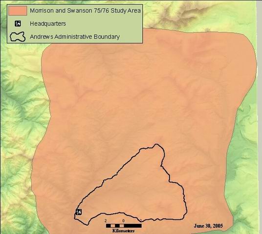
To define study area boundary.
Study area boundary for Morrison & Swanson unpublished reconnaissance study - 1975 and 1976
There are no credits for this item.
While substantial efforts are made to ensure the accuracy of data and documentation, complete accuracy of data sets cannot be guaranteed. All data are made available "as is". The Andrews LTER shall not be liable for damages resulting from any use or misinterpretation of data sets.
Extent
West | -122.324487 | East | -121.999875 |
North | 44.401096 | South | 44.167544 |
Maximum (zoomed in) | 1:5,000 |
Minimum (zoomed out) | 1:150,000,000 |
publication date
Access constraints: Available on-line
Use constraints: See data access policy at www.fsl.orst.edu/lter (especially the data use policy)
While substantial efforts are made to ensure the accuracy of data and documentation, complete accuracy of data sets cannot be guaranteed. All data are made available "as is". The Andrews LTER shall not be liable for damages resulting from any use or misinterpretation of data sets.
Obtain information off of WWW site, call contact person for special requests.
Call contact person for instructions and costs.
esri shapefile, polygon
esri
Internal feature number.
ESRI
Feature geometry.
ESRI
old identification number from esri coverage. values = 0
author
area of polygon in square meters. computer generated. needs to be recalculated if boundaries are modified. from the original coverage, not the shape area.
esri
value of the perimeter of the polygon in meters. value represents coverage format value, and would need to be updated for shapefile.
esri
acre value as calculaterd from area attribute field: value is in square meters
author
Study area boundary for Morrison & Swanson unpublished reconnaissance study - 1975 and 1976
To define study area boundary.
publication date
Available on-line
See data access policy at www.fsl.orst.edu/lter (especially the data use policy)
Metadata imported.
Metadata imported.
Boundary digitized from scanned copy of map from Morrison & Swanson (1990) fire history study.
Dataset copied.
While substantial efforts are made to ensure the accuracy of data and documentation, complete accuracy of data sets cannot be guaranteed. All data are made available "as is". The Andrews LTER shall not be liable for damages resulting from any use or misinterpretation of data sets.
Obtain information off of WWW site, call contact person for special requests.