Shapefile
Tags
managed forests, natural
forests, vegetation, Oregon, Willamette National Forests, HJ Andrews Experimental
Forest
To provide information on vegetation distribution of the HJ Andrews
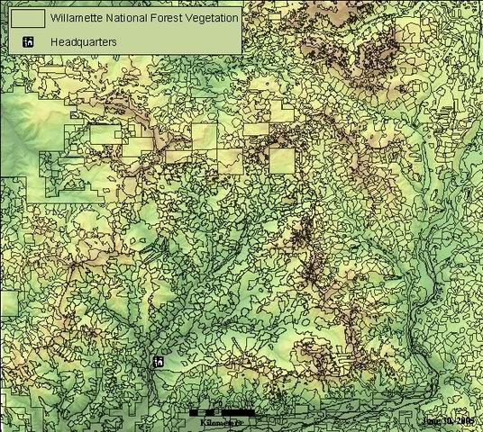
Vegetation map of the HJ Andrews, created by the Willamette National Forest using aerial photography and satellite imagery.
There are no credits for this item.
While substantial efforts are made to ensure the accuracy of data and documentation, complete accuracy of data sets cannot be guaranteed. All data are made available "as is". The Andrews LTER shall not be liable for damages resulting from any use or misinterpretation of data sets.
Extent
West | -122.382096 | East | -121.991200 |
North | 44.504130 | South | 44.120192 |
Maximum (zoomed in) | 1:5,000 |
Minimum (zoomed out) | 1:150,000,000 |
publication date
Access constraints: Available on-line
Use constraints: See data access policy at www.fsl.orst.edu/lter/data.fr.htm (especialy the data use policy)
While substantial efforts are made to ensure the accuracy of data and documentation, complete accuracy of data sets cannot be guaranteed. All data are made available "as is". The Andrews LTER shall not be liable for damages resulting from any use or misinterpretation of data sets.
Created by WNF using aerial photography and satellite imagery. (Willamette National Forest Veg6) Clipped to boundary of super-old growth study boundary by S. Giglia. Full metadata for current vegetation can be found at the following link: http://www.fs.fed.us/r6/willamette/manage/gis/veg8.htm
Obtain information off of WWW site, call contact person for special requests.
Call contact person for instructions and costs.
esri shapefile
esri
Internal feature number.
ESRI
Feature geometry.
ESRI
Area of feature in internal units squared.
esri
Perimeter of feature in internal units.
esri
A unique indentification number, carried over from coverage data source
esri
internal number, most likely unique, carried over from coverage data source
Willamette National Forest
stand number: Seven-digit index number for the polygon. This is the code that links to the WNF activites database.
Willamette NF Data Dictionary: National/Regional/Local application
code for the Willamette National Forest Ranger District (note that the districts have combined since this data was produced).
Willamette National Forest
original andrews GIS metadata (Word doc)
These codes are not documented and appear to have some errors, including null values for areas within the Andrews. Some of the values were identified by the Willamette National Forest GIS specialist.
Year of Origin for both natural and managed stands. The year of origin may indicate when a managed stand was certified as reforested. It does not take into account the age of seedlings if planted. Some units may have needed up to10 years to be certified. A value of 0 may indicate no-data.
Willamette NF Data Dictionary
predominant size class of trees MOMS - Mature and OverMature Survey (Willamette Natl Forest 1/91) was a stand condition mapping and old growth inventory project accomplished primarily by means of aerial photo-interpretation. Size class 5 from MOMS was redefined into size classes 5.1 and 6.1 using regression equations of crown diameter to predict size class. NOTE: THESE ARE VERY APPROXIMATE
Willamette NF Data Dictionary
most abundant tree species in primary canopy layer in managed or natural stand within national forest boundary.
original andrews GIS metadata (Word doc)
second most abundant tree species in primary canopy layer in managed or natural stands within the national forest boundary.
original andrews GIS metadata (Word doc)
estimated number of canopy layers
/data/fordata/oregon/willamette/hjandrews/hjaveg (Word doc)
method for overstory cut (activity code)
/data/fordata/oregon/willamette/hjandrews/hjaveg (Word doc)
year of last overstory cut or removal
original andrews GIS metadata (Word doc)
activity code (method) of most recent partial cut
original andrews GIS metadata (Word doc)
year of last partial cut
year of last commertial thinning
/data/fordata/oregon/willamette/hjandrews/hjaveg (Word doc)
unknown attribute
none
original inventory of stand species composition from the original timber inventroy used in Forest Plan Development
original andrews GIS metadata (Word doc)
condition class - based on dbh natural and partial cuts; based on age class for overstory cuts
original andrews GIS metadata (Word doc)
habitats with distinctive features that occur in a stand which may be important when considering mgmt practices Codes: Use this field to capture details about the stand such as presence of a landslide or bog. When multiple habitat features exist in a single stand, the dominant unique feature is attributed.
HJ Andrews Metadata (word doc)
percent of covered ground area covered by the vertical projection of live foliage of all trees in all canopy layers in a stand. Small openings are included; overlapping foliage is counted only once; canopy cover cannot exceed100%
original andrews GIS metadata (Word doc)
1
potential natural plant community; defined as discrete,recurring collections of plant species which maintain stable populations over a long period of time
original andrews GIS metadata (Word doc)
land classification which indicates the potential of a site for growing vegetation
original andrews GIS metadata (Word doc)
Vegetation map of the HJ Andrews, created by the Willamette National Forest
using aerial photography and satellite imagery.
To provide information on vegetation distribution of the HJ Andrews
publication date
Available on-line
See data access policy at www.fsl.orst.edu/lter/data.fr.htm (especialy the data
use policy)
Created by WNF using aerial photography and satellite imagery. (Willamette
National Forest Veg6) Clipped to boundary of super-old growth study boundary by
S. Giglia. Full metadata for current vegetation can be found at the following
link: http://www.fs.fed.us/r6/willamette/manage/gis/veg8.htm
Metadata imported.
009
1
009
While substantial efforts are made to ensure the accuracy of data and
documentation, complete accuracy of data sets cannot be guaranteed. All data are made
available "as is". The Andrews LTER shall not be liable for damages resulting from any
use or misinterpretation of data sets.
Local area network
Obtain information off of WWW site, call contact person for special
requests.