Shapefile
Tags
Douglas-fir, fire
history, super old growth, Blue River Watershed, Oregon, Willamette Basin, old growth, HJ
Andrews Experimental Forest
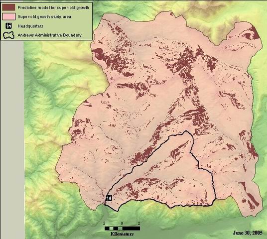
Created to identify areas within super-old growth study area that possessed the two attributes most strongly related to SOG occurrence: N aspect and slope gradient between 0-15 degrees.
Predictive model for super-old growth study. Shapefile derived from intersection of NW and NE aspects (from gen_aspect.shp) and slope class "1" (0-15 degree slope - from slope_class.shp).
There are no credits for this item.
While substantial efforts are made to ensure the accuracy of data and documentation, complete accuracy of data sets cannot be guaranteed. All data are made available "as is". The Andrews LTER shall not be liable for damages resulting from any use or misinterpretation of data sets.
Extent
West | -122.333109 | East | -122.035732 |
North | 44.406186 | South | 44.195795 |
Maximum (zoomed in) | 1:5,000 |
Minimum (zoomed out) | 1:150,000,000 |
ground condition
Access constraints: Available on-line
Use constraints: See data access policy at www.fsl.orst.edu/lter (especially the data use policy)
While substantial efforts are made to ensure the accuracy of data and documentation, complete accuracy of data sets cannot be guaranteed. All data are made available "as is". The Andrews LTER shall not be liable for damages resulting from any use or misinterpretation of data sets.
Obtain information off of WWW site, call contact person for special requests.
Call contact person for instructions and costs.
SOG predictive model
author
Internal feature number.
ESRI
Feature geometry.
ESRI
Aspect quadrant
author
slope position classification
author
Sub-area within study area - defined by watershed boundaries
author
unique number for the polygon
author
unknown
author
unknown
author
Sub-area within study area - defined by watershed boundaries
author
area in square meters
author
perimeter of each polygon in meters
author
acre value as calculated from square meter area field.
source
Predictive model for super-old growth study. Shapefile derived from intersection of NW and NE aspects (from gen_aspect.shp) and slope class "1" (0-15 degree slope - from slope_class.shp).
Created to identify areas within super-old growth study area that possessed the two attributes most strongly related to SOG occurrence: N aspect and slope gradient between 0-15 degrees.
ground condition
Available on-line
See data access policy at www.fsl.orst.edu/lter (especially the data use policy)
Metadata imported.
Shapefile "gen_aspect.shp" queried for NW and NE aspects. Shapefile "slope_class" queried for slope class "1" (0-15 degrees). Selections from the two shapefiles intersected to create this shapefile.
Dataset copied.
While substantial efforts are made to ensure the accuracy of data and documentation, complete accuracy of data sets cannot be guaranteed. All data are made available "as is". The Andrews LTER shall not be liable for damages resulting from any use or misinterpretation of data sets.
Obtain information off of WWW site, call contact person for special requests.