Shapefile
Tags
old growth, western Cascades,
Douglas-fir, fire history, Oregon, central western Cascades, HJ Andrews Experimental Forest,
super old growth
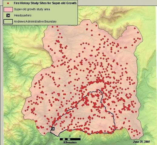
A permanent record of sample site locations and their spatial and temporal attributes for fire history studies in the central western Cascades from the mid-1970s to 2002
Synthesis of sample site locations from Morrison & Swanson (unpublished); Teensma (1987); Weisberg (1998) fire history studies, and Giglia (unpublished) supplemental data, used for super-old growth study, Giglia et. al. 2003.
Giglia, Morrison & Swanson, Weisberg, Teensma
While substantial efforts are made to ensure the accuracy of data and documentation, complete accuracy of data sets cannot be guaranteed. All data are made available "as is". The Andrews LTER shall not be liable for damages resulting from any use or misinterpretation of data sets.
Extent
West | -122.322426 | East | -122.039452 |
North | 44.396960 | South | 44.198444 |
Maximum (zoomed in) | 1:5,000 |
Minimum (zoomed out) | 1:150,000,000 |
Giglia, Morrison & Swanson, Weisberg, Teensma
ground condition
Access constraints: Available on-line
Use constraints: See data access policy at www.fsl.orst.edu/lter (especially the data use policy)
While substantial efforts are made to ensure the accuracy of data and documentation, complete accuracy of data sets cannot be guaranteed. All data are made available "as is". The Andrews LTER shall not be liable for damages resulting from any use or misinterpretation of data sets.
Obtain information off of WWW site, call contact person for special requests.
Call contact person for instructions and costs.
shapefile attribute table
esri
Internal feature number.
ESRI
Feature geometry.
ESRI
UTM easting coordinate
author
UTM northing coordinate
author
researcher-defined site identification
author
researcher ID
author
harvest clearcut date of sample site
author
0
severity code for fire from 1100-1199
author
severity code for fire from 1200-1299
author
severity code for fire from 1300-1399
author
severity code for fire from 1400-1499
author
severity code for fire from 1500-1599
author
severity code for fire from 1600-1699
author
severity code for fire from 1700-1799
author
severity code for fire from 1800-1899
author
severity code for fire from 1900-1999
author
presence/absence of SOG
author
number of centuries with fire recorded
author
Number of centuries with fire, excluding SOG centuries (interpreted as "centuries with fire after 1450"
author
elevation of site in meters
author
site classification of slope in degrees
author
site aspect classification
author
site slope position classification
author
Synthesis of sample site locations from Morrison & Swanson (unpublished);
Teensma (1987); Weisberg (1998) fire history studies, and Giglia (unpublished)
supplemental data, used for super-old growth study, Giglia et. al. 2003.
A permanent record of sample site locations and their spatial and temporal
attributes for fire history studies in the central western Cascades from the
mid-1970s to 2002
ground condition
Available on-line
See data access policy at www.fsl.orst.edu/lter (especially the data use
policy)
Giglia, Morrison & Swanson, Weisberg, Teensma
Data quality varies depending on source. See metadata for individual researcher
shapefiles for details on data quality.
This shapefile was created by merging the following shapefiles:
giglia_allsites; m&s_unpub_allsites; teensma_allsites; weisberg_allsites.
Attributes merged were: researcher, x and y coordinates and SOG
presence/absence.
Site elevation was derived from a spatial join between site point
locations and a 20m contour layer.
Fire chronology data were aggregated to century-scale and classified by
severity as follows: Severity Class codes included from Class codes included
from code: Definition: M & S/Teensma fire chron. Weisberg fire chron. H
hi-severity fire occurred at least once 3, 4 5,7 M mixed-severity fire " " " " 5
4 L low-severity fire " " " " 1,2 1,2 S site not included in previous fire
chronologies, but refer to sites where SOG exists; assumption is made that SOG
post-dates high-severity fire The fire chronologies referred to above are in ms
excel format: "BRCHRONO" (DF15) and "brmfc" - see Don Henshaw.
Elevation class was derived from a spatial join with "gen_aspect"
shapefile and refers to the slope position in relation to proximal high
ridges.
Slope class was derived from a spatial join with "slope_class" shapefile
and refers to the slope angle classified by degrees.
General aspect was derived from a spatial join with "gen_aspect" shapefile
and refers to the general aspect of a slope, ignoring
microtopography.
Metadata imported.
Metadata imported.
Dataset copied.
0
While substantial efforts are made to ensure the accuracy of data and
documentation, complete accuracy of data sets cannot be guaranteed. All data are made
available "as is". The Andrews LTER shall not be liable for damages resulting from any
use or misinterpretation of data sets.
Obtain information off of WWW site, call contact person for special
requests.