Shapefile
Tags
Oregon, fire history, Douglas-fir, super old growth, old growth, western Cascades, HJ Andrews Experimental Forest, central western Cascades
For spatial analysis of sampling density, search intensity and super-old growth locations.
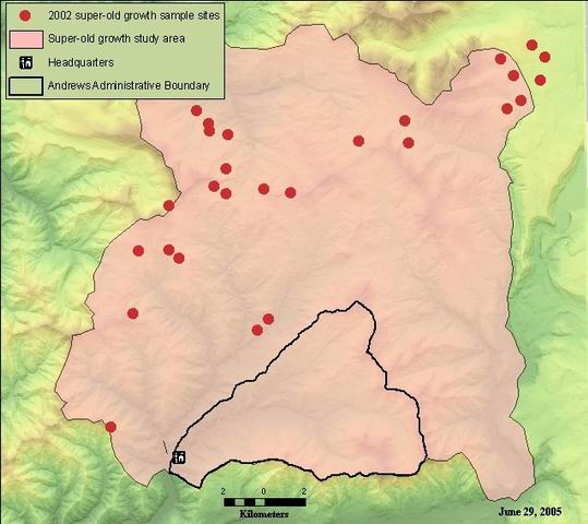
Sample site locations for supplemental field work done Sept. 2002 for super-old growth study.
Giglia
While substantial efforts are made to ensure the accuracy of data and documentation, complete accuracy of data sets cannot be guaranteed. All data are made available "as is". The Andrews LTER shall not be liable for damages resulting from any use or misinterpretation of data sets.
Extent
West | -122.297416 | East | -122.024923 |
North | 44.396499 | South | 44.223997 |
Maximum (zoomed in) | 1:5,000 |
Minimum (zoomed out) | 1:150,000,000 |
These data are also included in shapefile "sogstudy_allsites", which is a synthesis of samples site locations for multiple studies used in the super-old growth study.
Giglia
publication date
Access constraints: Available on-line
Use constraints: See data access policy at www.fsl.orst.edu/lter (especially the data use policy)
While substantial efforts are made to ensure the accuracy of data and documentation, complete accuracy of data sets cannot be guaranteed. All data are made available "as is". The Andrews LTER shall not be liable for damages resulting from any use or misinterpretation of data sets.
Obtain information off of WWW site, call contact person for special requests.
Call contact person for instructions and costs.
attribute table for shapefile
author
Internal feature number.
ESRI
Feature geometry.
ESRI
internal identification number
esri
Location identification of sample site, based on 1 sq. km grid overlaid on study area and coded A1 through AA26.
author
Date of harvest as derived from wnfveg6 coverage
author
1
tree ring count conducted in the field on oldest tree (if SOG exists) or most common age class
author
20
UTM easting coordinate
author
UTM northing coordinate
author
estimated origin year of oldest tree
author
presence/absence of SOG at this site
author
Sample site locations for supplemental field work done Sept. 2002 for super-old growth study.
For spatial analysis of sampling density, search intensity and super-old growth locations.
These data are also included in shapefile "sogstudy_allsites", which is a synthesis of samples site locations for multiple studies used in the super-old growth study.
publication date
Available on-line
See data access policy at www.fsl.orst.edu/lter (especially the data use policy)
Giglia
Sample site locations downloaded from GPS. Some manual editing of locations made to place point firmly inside the appropriate harvest unit as determined from overlaying points on a DOQ.
Fairly accurate; data derived from GPS. Point data represent 2D sample sites. All sites located within recent clearcut harvest units.
Sample site locations recorded with GPS unit. Table created in MS Excel with UTM x-y coordinates of sites. Point shapefile created from table of coordinates.
Metadata imported.
Dataset copied.
1
012
20
While substantial efforts are made to ensure the accuracy of data and documentation, complete accuracy of data sets cannot be guaranteed. All data are made available "as is". The Andrews LTER shall not be liable for damages resulting from any use or misinterpretation of data sets.
Obtain information off of WWW site, call contact person for special requests.