Shapefile
Tags
HJ Andrews Experimental Forest, Blue River Watershed, fire, vegetation, Willamette Basin, fire history, Oregon
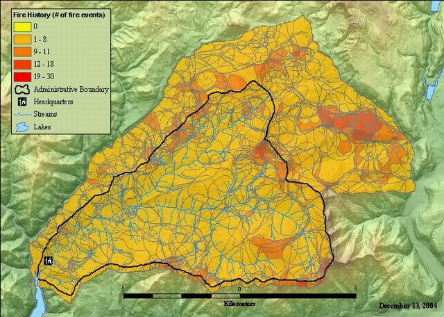
To document the fire history of the HJ Andrews and provide digital data for further analysis. This layer has individual polygons of the fire boundaries, merged into one layer. This layer is useful for analysis of overlapping fire events.
Fire History - H J Andrews and Vicinity (1482 - 1952) individual polygons. Fire history studies by Peter Teensma provide the base information for this layer. Individual fire episodes were manuscripted onto HJA base maps and digitized. Fire episodes were maintained in thirty one separate polygon coverages, until Arc/Info Version 7 provided the region feature class to accomodate overlapping polygons. REGIONPOLY was used to create regions for each fire episode and then the 31 episode regions were combined using UNION.
The field "AGE" = 0 means that a fire occured in the polygon. AGE = 1 means that fire was absent. COUNT indicates the number if fire events in that polygon.
.
There are no credits for this item.
While substantial efforts are made to ensure the accuracy of data and documentation, complete accuracy of data sets cannot be guaranteed. All data are made available "as is". The Andrews LTER shall not be liable for damages resulting from any use or misinterpretation of data sets.
Extent
West | -122.266082 | East | -122.055962 |
North | 44.307738 | South | 44.194632 |
Maximum (zoomed in) | 1:5,000 |
Minimum (zoomed out) | 1:150,000,000 |
ground condition
Access constraints: Available on-line
Use constraints: See data access policy at www.fsl.orst.edu/lter (especialy the data use policy)
While substantial efforts are made to ensure the accuracy of data and documentation, complete accuracy of data sets cannot be guaranteed. All data are made available "as is". The Andrews LTER shall not be liable for damages resulting from any use or misinterpretation of data sets.
Obtain information off of WWW site, call contact person for special requests.
Call contact person for instructions and costs.
fire history polygon attribute table
esri
Internal feature number.
ESRI
Feature geometry.
ESRI
Area of feature in internal units squared.
ESRI
Perimeter of feature in internal units.
ESRI
unique number generated by legacy arcinfo program.
esri
unique number generated by legacy arcinfo program.
esri
number of times a portion of the original polygon is in more than one year of fire occurance or year of no fire occurance (if not in any year)
FSL documentation
Presence of fire for episodes
FSL documentation
year of the fire episode
FSL documentation
Fire History - H J Andrews and Vicinity (1482 - 1952). Fire history studies by
Peter Teensma provide the base information for this layer. Individual fire episodes
were manuscripted onto HJA base maps and digitized.
To document the fire history of the HJ Andrews and provide digital data for
further analysis
ground condition
Available on-line
See data access policy at www.fsl.orst.edu/lter (especialy the data use
policy)
Data quality is good, with the provisio that any reconstruction of fire history from
tree ring data entails a fair bit on boundary uncertainty.
Fire history studies by Peter Teensma provide the base information for
this layer. Individual fire episodes were manuscripted onto HJA base maps and
digitized. Fire episodes were maintained in thirty one separate polygon
coverages, until Arc/Info Version 7 provided the region feature class to
accomodate overlapping polygons. REGIONPOLY was used to create regions for each
fire episode and then the 31 episode regions were combined using UNION.
Dataset copied.
Dataset copied.
While substantial efforts are made to ensure the accuracy of data and
documentation, complete accuracy of data sets cannot be guaranteed. All data are made
available "as is". The Andrews LTER shall not be liable for damages resulting from any
use or misinterpretation of data sets.
Obtain information off of WWW site, call contact person for special
requests.