Shapefile
Tags
disturbance, forest management, HJ
Andrews, Oregon, fire, WIllamette Basin, Blue River Watershed
To support research management within the HJ Andrews Experimental Forest
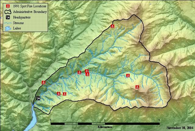
Spot fire locations from 1991, 2013, and 2015 fire seasons within the Andrews Experimental Forest
There are no credits for this item.
While substantial efforts are made to ensure the accuracy of data and documentation, complete accuracy of data sets cannot be guaranteed. All data are made available "as is". The Andrews LTER shall not be liable for damages resulting from any use or misinterpretation of data sets.
Extent
West | -122.249055 | East | -122.140306 |
North | 44.272017 | South | 44.215105 |
Maximum (zoomed in) | 1:5,000 |
Minimum (zoomed out) | 1:150,000,000 |
df01801 fire91
ground condition
m-f 0800-1630
none
While substantial efforts are made to ensure the accuracy of data and documentation, complete accuracy of data sets cannot be guaranteed. All data are made available "as is". The Andrews LTER shall not be liable for damages resulting from any use or misinterpretation of data sets.
The Data User will notify the Data Set Contact when any derivative work or publication based on or derived from the Data Set is distributed. The Data User will provide the data contact with two reprints of any publications resulting from use of the Data Set and will provide copies, or on-line access to, any derived digital products. Notification will include an explanation of how the Data Set was used to produce the derived work. Andrews Experimental Forest LTER Program Email: hjaweb@fsl.orst.edu Andrews Forest Director P.O. Box 300 Blue River, OR 97413
good
none
m-f 8:00am-4:00pm
Digitized inhouse from hard copy maps
Converted to shapefile from coverage. Projected from NAD27 to NAD 83
moving to newer formats.
updated from GPS coordinates and lat/long coordinates provided by McKenzie River Ranger District Fire personnel.
m-f 0800-1630
Digitized in-house from hard copy maps.
m-f 0800-1630
Obtain the data from the website: http://www.fsl.orst.edu/lter/datafr.htm Call the distribution number if you can not access the website.
1991 spot fires point attribute table
FSLDOC documentation
Internal feature number.
ESRI
Sequential unique whole numbers that are automatically generated.
Feature geometry.
ESRI
Coordinates defining the features.
unique number for featuire
esri
unique numbers for features
year fire occured
originator
m-f 0800-1630
Spot fire locations from the 1991 fire season within the Andrews Experimental Forest
To support research management within the HJ Andrews Experimental Forest
ground condition
Available on Line
See data access policy at www.fsl.orst.edu/lter/data.cfm (especially the data use policy)
good
Digitized inhouse from hard copy maps
Dataset copied.
Dataset copied.
009
While substantial efforts are made to ensure the accuracy of data and documentation, complete accuracy of data sets cannot be guaranteed. All data are made available "as is". The Andrews LTER shall not be liable for damages resulting from any use or misinterpretation of data sets.
Local area network
Obtain the data from the website: http://www.fsl.orst.edu/lter/datafr.htm
Call the distribution number if you can not access the website.